Asean Weather Nov. 18-24 2017 – Tropical depression ‘Tino’ continues to move away from PH – PDI
UPDATED: 09:37 AM November 18, 2017
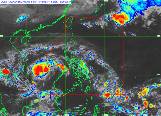
Tropical Depression “Tino” was last tracked at 305 km West Northwest of Puerto Princesa City, Palawan on Saturday morning as it continued to move away from the country, the weather bureau said.
“Tino” was packing maximum sustained winds of up to 55 km/h and gusts of up to 80 km/h, the Philippine Atmospheric, Geophysical and Astronomical Services Administration (Pagasa) said in its 3:00 a.m. forecast.
Pagasa said “Tino” will maintain its West Northwest movement at 28 km/h, and is expected to exit the Philippine area of responsibility later this morning.
<>
ADVERTISEMENT: This space is reserve for your Ad, contact aseanews.net now!
Because of the weather system and the easterlies, the weather bureau said Visayas, Bicol region, MIMAROPA and provinces of Cagayan, Aurora and Quezon will experience cloudy skies with scattered rains and thunderstorms.
Meanwhile, regions of Ilocos, Cordillera and Batanes will also experience partly cloudy to cloudy skies with isolated light rains due to northeast monsoon.
Due to localized thunderstorms, Metro Manila and the rest of the country will have partly cloudy to cloudy skies with isolated rain showers.
Courtesy:
.
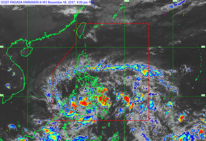
MANILA, Philippines — The Philippine Atmospheric, Geophysical and Astronomical Services Administration (PAGASA) yesterday monitored a low-pressure area that may develop into a tropical depression within the next 24 hours.
At 3 p.m. yesterday, the low-pressure area was estimated at the vicinity of Malaybalay, Bukidnon and will bring cloudy skies with scattered to widespread rains and thunderstorms over the regions of Caraga, Northern Mindanao, Zamboanga peninsula, Eastern and Central Visayas and Lanao del Sur.
<>
ADVERTISEMENT: This space is reserve for your Ad, contact aseanews.net now!
<>
Residents in those areas are alerted for possible flashfloods and landslides. The Bicol region and the rest of the Visayas and Mindanao will have cloudy skies with scattered rains and thunderstorms due to the weather disturbance while the Ilocos, Cordillera and Cagayan regions will experience partly cloudy to cloudy skies with isolated light rains due to the northeast monsoon, PAGASA added.
Metro Manila and the rest of Luzon and the Visayas will have partly cloudy to cloudy skies with isolated rainshowers because of localized thunderstorms.
“Should the low-pressure area develop into a tropical depression, maritime operations along the Bohol Sea including the seaboards of Surigao provinces, Southern Leyte, southern Negros Oriental and Zamboanga del Norte will be disrupted,” PAGASA noted.
Courtesy: (The Philippine Star) | Updated November 17, 2017 – 12:00am
<>
NOTE : All photographs, news, editorials, opinions, information, data, others have been taken from the Internet ..aseanews.net | [email protected] |
For comments, Email to :
Aseanews.Net | [email protected] | Contributor