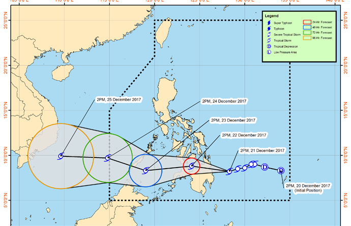
Asean Weather Dec. 23-29 2017 : Typhoon “VINTA” moving in th direction of South China Sea towards Viet Nam expected to exit Philippine on Monday
(image from the Philippine Atmospheric Geophysical and Astronomical Services Administration (Pagasa) )
.
Tropical Storm Vinta has further weakened as it continuously tracked the path leading to Misamis Oriental-Zamboanga Del Norte area.
In its severe weather bulletin at 2 p.m., the Philippine Atmospheric Geophysical and Astronomical Services Administration (Pagasa) noted that Vinta was last seen at 1 p.m. on Friday in the vicinity of Marawi City having maximum sustained winds of 65 kph near the center and gustiness of up to 110 kph.
State weather forecasters expect Vinta to trek the western direction at 20 kph.
Pagasa noted that Tropical Cyclone Warning Signal No. 2 remains over the Misamis Oriental, Lanao del Norte, Lanao del Sur, Misamis Occidental, Zamboanga del Norte, Zamboanga del Sur, and Zamboanga Sibugay with wind speeds expected in the range of 60 to 120 kph:
In these areas, wave heights from 4.1 to 14 meters are possible due to storm surges at the coastal areas.
Signal No. 1 remains hoisted over Southern Leyte, Bohol, Southern Cebu, Negros Oriental, Southern Negros Occidental, Siquijor, Agusan del Sur, Bukidnon, Davao del Norte, Dinagat Island, North Cotabato, Surigao del Norte, Surigao del Sur, Agusan del Norte, Camiguin, Compostela Valley, Northern Davao del Sur (Davao City) and Maguindanao.
These areas are expected to experience 30 to 60 kph winds in the next 36 hours as wave heights from 1.25 to 4 meters are likely in open sea.
Vinta is expected to exit the Philippine Area of Responsibility on Monday morning.
Tags: Misamis Oriental, Philippine Atmospheric Geophysical, Typhoon Vinta, Vinta, weather bulletin, Zamboanga del Norte,
COURTESY:
THE MANILA BULLETIN
Updated By Chito Chavez
.
NOTE : All photographs, news, editorials, opinions, information, data, others have been taken from the Internet ..aseanews.net | [email protected] |
For comments, Email to :
Icarus d’ Greek | [email protected] | – Contributor


