
ASEANEWS HEADLINE-WEATHER: STORM ‘Wipha’ / ‘Crising’ | ASEAN: Tropical depression forecast to strengthen into storm
A tropical depression over the eastern waters of the Philippines has strengthened into Storm Wipha. VNA/VNS Photo
.
WATCH VIDEO: https://www.youtube.com/watch?v=ide16aXO5Us
Tropical Storm Wipha / Bagyo Crising update, flooding rains in the Philippines and a new storm
.
.
.
Weather
8 areas under Signal No. 2 as ‘Crising’ threatens Northern Luzon landfall

Satellite rendering shows Tropical Storm Crising taken as of 7:20 a.m. on July 18, 2025.
.
.
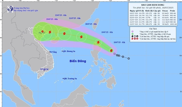
HÀ NỘI — A tropical depression over the eastern waters of the Philippines has strengthened into Storm Wipha early on Friday, according to the National Centre for Hydro-Meteorological Forecasting.
As of 1am on Friday, the storm’s centre was located at approximately 16.4 degree North latitude and 125.3 degree East longitude, over the eastern waters of Luzon Island (the Philippines). Maximum sustained winds near the centre reached between 62–74 kph. The storm was moving northwest at around 20kph.
By 1am on Saturday, Wipha is expected to continue northwestward over the northern waters of Luzon, maintaining a speed of 20kph and likely gaining strength, with winds of 62-88kph and gusts reaching level 103-117kph.
.
 |
.
By 1am on Sunday, the storm is forecast to move west-northwest at 20–25 kph, located about 740km southeast of China’s Leizhou Peninsula. It is expected to enter the East Sea (internationally known as the South China Sea) and further intensify, with sustained winds reaching 89-102kph. The northeastern area of the northern East Sea will be affected. The current disaster risk level is rated at Level 3.
By 1am on Monday, the storm will continue moving west-northwest, about 220 km east of the Leizhou Peninsula, with sustained winds expected to increase to 103-117kph. The affected area remains the northern part of the northern East Sea, with disaster risk still at Level 3.
.
|
|
.
In the following 72 to 120 hours, Wipha is forecast to continue moving west-northwest at a steady speed of around 20 kph.
Due to the storm’s influence, from the afternoon of Friday, the eastern part of the northern East Sea will see strong winds. Sea waves are expected to reach heights of 2.5 to 3.5m, with rough seas and hazardous conditions for marine traffic, including thunderstorms, squalls, and large waves.
In response, the Ministry of Agriculture and Environment has urged localities and relevant ministries to closely monitor the storm’s developments, strictly manage vessels going out to sea, and promptly notify ship owners and captains about the system’s location and trajectory to avoid entering dangerous areas.
Authorities are also advised to review and implement safety measures for ports, tourism areas, aquaculture farms, and coastal zones.
Proactive plans should be in place to safeguard homes, warehouses, public buildings, industrial zones, factories, power and telecommunications systems, agricultural production, and flood-prone areas in urban and industrial zones. — VNS
.
Weather
8 areas under Signal No. 2 as ‘Crising’ threatens Northern Luzon landfall
MANILA, Philippines — Tropical Storm Crising has intensified and is expected to make landfall over Cagayan or the Babuyan Islands by Friday afternoon or evening.
In its 8 a.m. bulletin, state weather bureau PAGASA said Crising was last seen 250 kilometers east of Tuguegarao City, Cagayan.
It packed maximum sustained winds of 65 kilometers per hour near the center and gusts reaching 80 kph.
Crising is moving northwest at 15 kph.
.
|
|
.
Wind Signals
The state weather bureau hoisted the following tropical cyclone wind signals in several areas:
Signal No. 2
- Batanes
- Cagayan including Babuyan Islands
- The northern and eastern portions of Isabela (Palanan, Ilagan City, Divilacan, Delfin Albano, Quezon, Tumauini, Maconacon, Santa Maria, Cabagan, San Pablo, Santo Tomas, San Mariano, Dinapigue)
- Apayao
- The northern portion of Kalinga (City of Tabuk, Balbalan, Pinukpuk, Rizal)
- The northern portion of Abra (Malibcong, Lacub, Lagangilang, Licuan-Baay, Danglas, Lagayan, San Juan, Tineg, La Paz, Dolores)
- Ilocos Norte
- The northern portion of Ilocos Sur (Cabugao, Sinait)
Residents in these areas should prepare for minor to moderate threat to life and property due to winds ranging from 62 to 88 kph.
.
|
|
.
Signal No. 1
- Rest of Isabela
- Quirino
- Nueva Vizcaya
- Rest of Kalinga
- Mountain Province
- Ifugao
- Rest of Abra
- Benguet
- Rest of Ilocos Sur
- La Union
- Northern portion of Pangasinan (San Nicolas, Natividad, San Quintin, San Manuel, Tayug, Sison, San Fabian, Pozorrubio, Laoac, Binalonan, San Jacinto, Manaoag, Mangaldan, Dagupan City, Binmaley, Lingayen, Labrador, Sual, City of Alaminos, Bolinao, Anda, Bani, Agno, Burgos, Mabini, Dasol, Calasiao, Santa Barbara, Mapandan, Bugallon)
- Northern portion of Aurora (Dilasag, Casiguran, Dinalungan, Dipaculao, Baler, Maria Aurora)
- Northeastern portion of Nueva Ecija (Carranglan, Pantabangan)
Areas under Signal No. 1 may experience strong winds ranging from 39 to 61 kph, which could cause minimal to minor damage.
|
|
.
Track, intensity outlook
PAGASA said Crising is moving northwestward and is expected to cross parts of Extreme Northern Luzon before exiting the Philippine area of responsibility (PAR) by Saturday afternoon.
“On the forecast track, a landfall scenario over mainland Cagayan or Babuyan Islands this afternoon or evening is possible,” the state weather bureau said.
Crising is also expected to intensify further, reaching severe tropical storm category by Saturday morning or afternoon.
.
.
PREVENT CLIMATE CHANGE

 Memento Maxima Digital Marketing