

ASEANEWS HEADLINE-WEATHER: STORM ‘Wipha’ / ‘Crising’ | ASEAN: MANILA: ‘Crising’ roars toward Northern Luzon | HÀ NỘI: Typhoon Wipha gains strength, set to impact northern Việt Nam on July 22
Forecasted path of Typhoon Wipha over the next few days. — Photo vndms.dmc.gov.vn
.
WATCH VIDEO: https://www.youtube.com/watch?v=JSi5uAbWgMY
Tropical Bagyo Crising Wipha update and a new storm possible Dante, westpacwx tropical update
.
.
WATCH VIDEO: https://www.youtube.com/watch?v=DBL95IIKKGs
Press Briefing -Tropical Storm Crising {WIPHA} at 5AM | July 19, 2025 – Saturday
.

MANILA, Philippines — Tropical Storm Crising intensified on Thursday afternoon as it approached Northern Cagayan, prompting the Philippine Atmospheric, Geophysical and Astronomical Services Administration (PAGASA) to raise Tropical Cyclone Wind Signal No. 2 over more than 30 areas in Northern Luzon, which are bracing for gale-force winds and intense rainfall.
As of 4 p.m. yesterday, Crising (international name Wipha) was located 135 kilometers east-northeast of Tuguegarao City, Cagayan, or 135 kilometers east of Aparri, Cagayan. It was packing maximum sustained winds of 75 kilometers per hour near the center and gusts of up to 105 kph, while moving west-northwestward at 20 kph, according to PAGASA.
Under Signal No. 2 are Batanes, Cagayan, including the Babuyan Islands, Isabela, Apayao, Kalinga, Ilocos Norte, and parts of Ilocos Sur, Abra, Mountain Province and Ifugao. These areas may experience gale-force winds within 24 hours and are at risk of minor to moderate damage to life and property.
.
 |
.
In Abra, the northern and central towns – including Manabo, Pidigan, Tayum, Boliney, Bucloc, La Paz and Lagayan – are under Signal No. 2. The same alert was raised over the eastern portions of Mountain Province (Natonin and Paracelis) and Ifugao (Aguinaldo and Alfonso Lista) as well as northern Ilocos Sur, including Vigan City and surrounding municipalities.
The weather bureau warned that stormy weather and heavy to torrential rainfall could trigger floods and landslides in these areas. Local winds may be stronger in coastal and mountainous areas directly exposed to the storm’s circulation
.
|
|
.
Tropical Cyclone Wind Signal No. 1 remains in effect over several other parts of Luzon, including Quirino, Nueva Vizcaya, Benguet, the rest of Abra and Ilocos Sur, La Union, northern Aurora, northeastern Nueva Ecija and northern Pangasinan.
Crising, according to PAGASA, was expected to make landfall over the northeastern portion of mainland Cagayan or the Babuyan Islands yesterday evening. It was forecast to move northwestward and exit the Philippine area of responsibility by afternoon today. The storm may continue to intensify and reach severe tropical storm category by tonight or early tomorrow.
Beyond the wind threat, Crising is also enhancing the southwest monsoon, which is bringing rains to Central and Southern Luzon, the Visayas and Mindanao. Monsoon rains are expected in Metro Manila, Zambales, Bataan, Batangas, Cavite, Occidental Mindoro, Palawan and Western Visayas, with possible flooding and landslides.
Occasional to scattered rains are forecast in the rest of Luzon, Central Visayas and the Zamboanga Peninsula, while the remaining parts of the country may experience cloudy skies with scattered rains and thunderstorms.
A storm surge of up to two meters is possible within 24 hours in low-lying coastal areas of Batanes, Cagayan, including Babuyan Islands, Ilocos Norte and Ilocos Sur.
PAGASA also issued a gale warning for the seaboards of Northern Luzon, where sea conditions may reach up to six meters, making sea travel dangerous for all types of vessels.
Mariners are strongly advised to remain in port and seek shelter until weather conditions improve. Sea conditions remain rough to very rough in many areas across Luzon, Visayas and Mindanao due to the combined effects of Crising and the southwest monsoon.
Authorities are urging residents, particularly those in high-risk areas under Signal No. 2, to monitor updates and follow evacuation or precautionary instructions from local officials.
Emergency funds, relief goods on standby
The government has readied P2.9 billion worth of standby funds and relief goods – comprising more than three million family food packs (FFP) and with at least 28,107 ready-to-eat food boxes and 334,791 non-food items – to be used for areas that are likely to be affected by Crising and the enhanced southwest monsoon, Malacañang said.
President Marcos visited yesterday the National Resource Operation Center (NROC) of the Department of Social Welfare and Development (DSWD) in Pasay City to personally oversee the preparation of FFPs and other relief items.
.
|
|
.
“Hopefully, the storm won’t intensify. But if it does, we are ready,” the President told reporters in Filipino.
He said all warehouses of the DSWD, especially in Northern Luzon, have sufficient supply of relief goods.
Marcos was accompanied by Social Welfare Secretary Rex Gatchalian during his visit to the NROC.
.
Ahead of Crising, the DSWD already prepositioned three million FFPs across 934 storage hubs nationwide, complemented by the continuous production of new relief supplies at the agency’s main warehouses, the NROC and the Visayas Disaster Resource Center (VDRC) in Mandaue City in Cebu province.
The new mechanized packing system in NROC, combined with the new system in VDRC, is capable of producing 52,000 boxes of FFPs a day.
Gatchalian also directed all DSWD field offices nationwide to make sure that disaster response personnel will be immediately deployed, and relief goods swiftly distributed to areas in need of aid, any time of the day.
Aside from FFPs, hygiene kits and medicines, Marcos said the DSWD was also testing water filters to be used by evacuees, which can filter any kind of water – except for saltwater – to produce potable water.
The President was seen drinking the filtered water from a container.
Meanwhile, Marcos ordered the establishment of additional disaster response centers in the country to be used during calamities and emergencies, according to Presidential Communications Undersecretary Claire Castro.
In the meantime, the Department of Human Settlements and Urban Development yesterday directed all its regional offices to convene their respective shelter teams to monitor and respond to families who may be displaced or whose homes may be damaged by Crising.

Class suspensions
Many areas in Luzon declared the suspension of classes yesterday.
Face-to-face classes were suspended in all levels, both public and private in Batangas, Cavite, Rizal, Bataan, Catanduanes, Ilocos Norte, Ilocos Sur; Luna and Bangar, La Union; Concepcion, Tarlac; Bocaue and Norzagaray, Bulacan; Dagupan City, Alaminos City, Infanta, San Jacinto, Pozorrubio, Rosales and Umingan, Pangasinan; Claveria and Santa Praxedes, Cagayan; San Vicente, Palawan; Negros Oriental; Binalbagan, Cauayan, Calatrava, Hinigaran, Sipalay City and Talisay City, Negros Occidental.
Other areas where in-person classes were suspended in all levels in both public and private were Naga City, Magsaysay, Occidental Mindoro, Siquijor, Cebu City; San Joaquin and Pavia, Iloilo; Zamboanga City; Manukan, Zamboanga del Norte; and Magsaysay, Misamis Oriental.
Meanwhile, classes in pre-school to senior high school both public and private were suspended in Laguna, Quezon, Baguio City; Talavera, Nueva Ecija; Sibalom, Antique; Malolos City and San Jose del Monte City, Bulacan; Belison, Hamtic and Valderama, Antique; Vinzons and Daet, Camarines Norte; and Sanchez Mira and Santo Niño, Cagayan.
In Metro Manila, only Manila, Makati and Navotas did not cancel classes out of the 17 cities and a municipality.
Manila City Administrator Eduardo Quintos XIV said based on data of the Manila City Disaster Risk Reduction and Management Office, only light rain was expected in the city, which was the basis for the non-cancellation of classes.
Valenzuela was the first to announce the suspension of online and in-person classes for kindergarten to senior high school for public and private, as well as in Pamantasan ng Lungsod ng Valenzuela and Valenzuela City Technological College.
Taguig suspended in-person classes from kinder to Grade 12 in both public and private schools.
Meanwhile, Marikina, Caloocan, Parañaque, San Juan, Mandaluyong, Las Piñas, Muntinlupa, Pasay, Pasig and Pateros suspended in-person classes in all levels both public and private.
The Quezon City government declared suspension of afternoon face-to-face classes for public schools from child development centers, kindergarten, Grades 1 to 12, and the alternative learning system.
In Malabon, online and in-person classes in all levels both public and private were suspended yesterday. The city government activated its disaster preparedness and response systems ahead of the possible impact of Crising.
Mayor Jeannie Sandoval said all necessary resources have been mobilized, including rescue equipment, early warning systems, relief goods, and pre-identified evacuation centers across 21 barangays.
1,024 stranded passengers – PCG
The Philippine Coast Guard (PCG) yesterday said the number of passengers stranded reached 1,024, as travel by sea was suspended in at least 32 ports.
The PCG said that at least 348 rolling cargoes, 50 vessels and 45 motor bancas were also affected, while 35 vessels and 12 motor boats were taking shelter.
In Eastern Visayas, at least 696 passengers, 255 rolling cargoes, four vessels and one motorboat were affected in Palompon Port, Port of San Juan, Port of Maasin, Port of Benit, Port of Liloan, Magallanes/Triana Port and Port of Padre Burgos.
The PCG said that in Southwestern Mindanao, the stranded passengers in Port of Zamboanga, Sangali Fish Port, Dapitan Fish Port, Galas Feeder Port, Nabilid Port, Lamao Port, Dacon Fish Port and Palit Port reached 117, including 58 rolling cargoes and 16 vessels.
In Northern Mindanao, at least 159 passengers, 30 rolling cargoes and four vessels were affected at the Port of Plaridel, Port of Balingoan and Port of Guinsiliban.
In Western Visayas, at least 48 passengers, one vessel and seven motorboats were affected in Dapdap Pier and RJL Port.
In Barangay Sicsican, Puerto Princesa City, Palawan yesterday, the PCG rescued 88 families amid flooding. In Ilog, Negros Occidental, the PCG evacuated 151 residents affected by flooding.
Thousands evacuated
In Negros Occidental, more than 5,600 people have been forced into evacuation centers, as heavy rains hit 13 towns and cities, for a second day, the Provincial Disaster Risk Reduction and Management Council said yesterday.
Two people died of electrocution in Hinobaan town, while a fisherman was reported missing in Sagay City on Thursday.
Gov. Eugenio Jose Lacson reported the 5th and 6th districts of Negros Occidental were hit by flooding, while evacuation of affected residents, is still ongoing.
Lacson said he expects some local governments heavily affected by the flooding will declare a state of calamity.
Provincial Disaster Risk Reduction and Management Officer Irene Bel Plotena also reported flash floods in Pontevedra yesterday.
Negros Occidental 5th District Rep. Emilio Bernardino Yulo reported landslides along the secondary national road, which connects La Castellana, Negros Occidental, to Canlaon City, Negros Oriental.
Yulo added that all the towns and cities in 5th district of Negros Occidental, including La Castellana, which is the hardest hit by the Kanlaon volcano eruption, Moises Padilla, Isabela, Hinigaran, Binalbagan and Himamaylan City, experienced flooding.
Two houses were carried away by strong current in Barangays Crossing Magallon and Poblacion 1 in Moises Padilla, according to local disaster risk reduction officer Vincent Garcia.
Flights affected, courts suspended
At least 54 domestic flights were affected yesterday by adverse weather conditions brought by Crising, the Civil Aviation Authority of the Philippines said.
CAAP spokesman Eric Apolonio said 11 flights from Cebgo, 22 flights from Cebu Pacific, five flights from PalExpress and eight from Philippine Airlines were cancelled.
Trial courts in Metro Manila and several provinces suspended their operations yesterday.
In a series of posts on X, the Supreme Court Public Information Office said court operations in several areas were suspended due to the inclement weather including courts in Narvacan, San Juan, Magsingal, Tagudin, Vigan City and Candon City in Ilocos Sur. — Jose Rodel Clapano, Bella Cariaso, Rudy Santos, Ric Sapnu, Cesar Ramirez, Jun Elias, Gilbert Bayoran, Mark Ernest Villeza, Elizabeth Marcelo, Helen Flores
|
|
.
Typhoon Wipha gains strength, set to impact northern Việt Nam on July 22
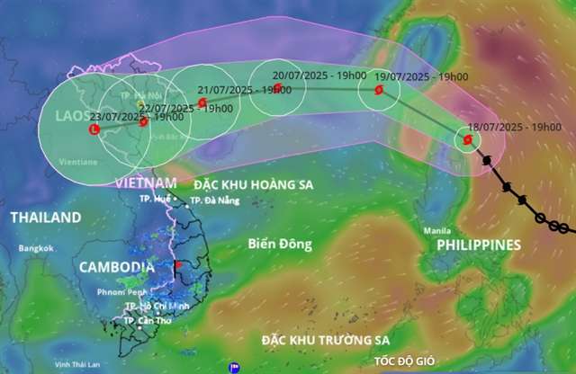 |
| Forecasted path of Typhoon Wipha over the next few days. — Photo vndms.dmc.gov.vn |
HÀ NỘI — Typhoon Wipha is expected to intensify as it moves into the East Sea (internationally known as the South China Sea), with forecasts showing it could make landfall in northern Việt Nam as early as July 22, bringing heavy rain and strong winds across a wide area.
The Ministry of Agriculture and Environment convened an emergency meeting on Friday to prepare for the storm, which is likely to become the third tropical cyclone to enter Vietnamese waters this year.
.
|
|
.
“From the start of the year, we’ve seen unusual weather patterns. Wipha is expected to bring heavy rainfall once it reaches land,” said Deputy Minister Nguyễn Hoàng Hiệp.
According to Mai Văn Khiêm, Director of the National Center for Hydro-Meteorological Forecasting, Wipha has been moving northwest at about 20 km/h, with developing convective clouds indicating a favorable environment for the storm to grow stronger.
“It will likely enter the East Sea by the morning of July 19 and be officially designated as Typhoon No.3. There is a high probability – over 90 per cent – that it will continue to intensify,” Khiêm said.
Forecasts show the storm could bring gusts up to Beaufort Force 15 (167-183 km/h) as it passes near Leizhou Peninsula (China). By the time it impacts Việt Nam’s northern coast on July 22, wind speeds could reach Beaufort Force 11 (103–117 km/h).
.
|
|
.
However, Khiêm noted that current weather models show significant variation in the storm’s potential path, with landfall estimates differing by up to 100 km. Rainfall and wind impacts will depend heavily on the storm’s actual trajectory.
As early as July 20, outer rainbands may bring scattered thunderstorms. From July 21 to 24, Wipha is forecast to cause widespread heavy rain across Northern Việt Nam and parts of North Central Coast, especially from Quảng Ninh to Nghệ An.
Rainfall totals are expected to reach 200–350 mm, with some locations possibly approaching 500–600mm. These projections remain preliminary and are expected to be updated as the storm nears.
If Wipha tracks further north along the Chinese coast, its effects on Việt Nam could be reduced. Updated forecasts are expected in the emergency storm bulletin on July 20.
Nguyễn Trường Sơn, Deputy Director of the Vietnam Disaster and Dike Management Authority, reported that as of 11.00 am on July 18, more than 35,000 vessels and 147,000 crew members had been notified and counted.
.
|
|
.
“There are no vessels currently operating in the northeastern part of the northern East Sea, which is expected to be most affected by the storm,” Sơn said.
Authorities are also closely monitoring major hydropower and irrigation reservoirs. At Hòa Bình Reservoir, three spillway gates are open to bring the water level down from 102.94 m to the seasonal flood safety level of 101 m. A similar drawdown is underway at Tuyên Quang Reservoir.
Officials are urging people to remain vigilant, stay informed through official updates and prepare for potential disruptions as the storm moves closer to shore. — VNS
.
.
PREVENT CLIMATE CHANGE

 Memento Maxima Digital Marketing