
ASEANEWS WEATHER-TYPHOON | Typhoon Kalmaegi /Tinio tracked northwest of Kudat, Sabah
Cambodia is expected to experience mild weather impacts from two tropical storms — Typhoon Kalmaegi (T2525) and Typhoon Fung-wong (T2526) — as the kingdom lies near their projected paths, according to the Ministry of Water Resources and Meteorology (MOWRAM).
.
CAMBODIA:
Cambodia to Experience Mild Impact from Typhoons Kalmaegi and Fung-wong
 Cambodia is expected to experience mild weather impacts from two tropical storms — Typhoon Kalmaegi (T2525) and Typhoon Fung-wong (T2526) — as the kingdom lies near their projected paths, according to the Ministry of Water Resources and Meteorology (MOWRAM).
In its announcement, the ministry stated that a low-pressure system forming over the western Pacific Ocean has strengthened into Typhoon Fung-wong (T2526), following the earlier development of Typhoon Kalmaegi (T2525).

Due to Cambodia’s proximity to the movement routes of both storms, the country is expected to be affected at around 20 percent intensity during the period from November 6 to November 15.
MOWRAM has advised the public to stay alert to weather updates and take precautionary measures, particularly in areas vulnerable to heavy rain, gusty winds, and localized flooding.
.
MALAYSIA:
Typhoon Kalmaegi tracked northwest of Kudat, Sabah – MetMalaysia
Typhoon Kalmaegi tracked northwest of Kudat, Sabah – MetMalaysia
…

@[email protected]
.
PHILIPPINES:
Typhoon Kalmaegi kills 140 in central Philippines, l127 missing, floods Cebu, and heads toward Vietnam with dangerous winds.
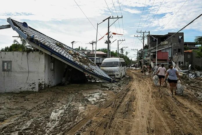 Residents walk along a mud covered street in the aftermath of Typhoon Kalmaegi in Liloan, in the province of Cebu on November 6, 2025. The death toll from Typhoon Kalmaegi in the central Philippines climbed past 100, as the devastating impact on Cebu province became clearer after the worst flooding in recent memory. (Photo by Jam STA ROSA / AFP)
.
LILOAN: Typhoon Kalmaegi killed at least 140 people and left another 127 missing after unleashing devastating flooding across the central Philippines, official figures showed Thursday, as the storm headed towards Vietnam.
Floodwaters described as unprecedented rushed through Cebu province’s towns and cities this week, sweeping away cars, riverside shanties and even massive shipping containers.
The national civil defence office confirmed on Thursday 114 reported deaths, though that tally did not include an additional 28 recorded by Cebu provincial authorities.
In Liloan, a town near Cebu City where 35 bodies have been recovered from flooded areas, AFP reporters saw cars still piled atop each other by floodwaters and roofs torn off buildings as residents attempted to dig out of the mud.
Christine Aton’s sister Michelle, who has a disability, was among Liloan’s victims, trapped in her bedroom as the floodwaters rose inside their house.
“We tried to pry open (her bedroom door) with a kitchen knife and a crowbar but it wouldn’t budge…. Then the refrigerator started to float,” Aton, 29, said.
“I opened a window and my father and I swam out. We were crying because we wanted to save my older sister.
“But my father told me we couldn’t do anything for her, that all three of us might end up dead.”
On neighbouring Negros Island, where at least 30 people were killed, Kalmaegi’s driving rain loosened volcanic mudflow that buried homes in Canlaon City, police Lieutenant Stephen Polinar told AFP on Wednesday.
“Eruptions of Kanlaon volcano since last year deposited volcanic material on its upper sections. When the rain fell, those deposits rumbled down onto the villages,” he told AFP.
The national death tally included six crew members of a military helicopter that crashed while on a typhoon relief mission.
‘The water was raging’
On Wednesday, residents of Cebu’s most-affected areas were busily cleaning up streets that had been rivers less than 24 hours earlier
“Around four or five in the morning, the water was so strong that you couldn’t even step outside,” said Reynaldo Vergara, 53, adding that everything in his small shop in Mandaue had been lost when a nearby river overflowed.
.”Nothing like this has ever happened. The water was raging.”
In nearby Talisay, where an informal settlement along a riverbank was washed away, AFP found 26-year-old Regie Mallorca already at work rebuilding his home.
“This will take time because I don’t have the money yet. It will take months,” he said as he mixed cement and sand atop the rubble.
The area around Cebu City was deluged with 18.3 centimetres (around seven inches) of rain in the 24 hours before Kalmaegi’s landfall, well over its 13.1 centimetre monthly average, weather specialist Charmagne Varilla told AFP.
On Tuesday, provincial governor Pamela Baricuatro called the situation “unprecedented” and “devastating”.
Scientists warn that storms are becoming more powerful due to human-driven climate change. Warmer oceans allow typhoons to strengthen rapidly, and a warmer atmosphere holds more moisture, meaning heavier rainfall.
In total, nearly 800,000 people were moved from the typhoon’s path.
‘Urgent and dangerous’
Kalmaegi was gathering strength on Thursday as it headed towards neighbouring Vietnam, where fear was mounting that the typhoon could compound the damage of a week of flooding that has already claimed 47 lives.
As of 8 am, the storm boasted windspeeds of 155 kilometres (96 miles) per hour and gusts of up to 190 kph.
The typhoon is forecast to make landfall in central Vietnam late Thursday, bringing waves as high as eight metres (26 feet) and powerful storm surges, according to the national weather bureau.
Deputy Prime Minister Tran Hong Ha urged local authorities to treat Kalmaegi as “urgent and dangerous”, calling it “a very abnormal” storm in a statement Wednesday.
Ten typhoons or tropical storms usually affect Vietnam, directly or offshore, in a given year, but Typhoon Kalmaegi is set to be the 13th of 2025.
The Philippines has already reached its average of 20 such storms a year with Kalmaegi, weather specialist Varilla told AFP, adding at least “three to five more” storms could be expected by December’s end. – AFP
@[email protected]
.
….
VIETNAM:
Typhoon Kalmaegi moves faster, now about 310km from Quy Nhơn
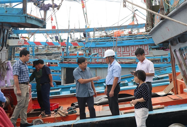 |
| Deputy Minister of Agriculture and Environment Nguyễn Hoàng Hiệp (centre) conducts an on-site inspection at a fish port and the Tịnh Hòa storm shelter in Đông Sơn Commune, Quảng Ngãi Province. — VNA/VNS Photo Cao Nguyên |
.
HÀ NỘI — Typhoon Kalmaegi, the 13th storm in the East Sea (internationally known as the South China Sea) this year, has maintained its direction and intensity but is moving faster, according to the National Centre for Hydro-Meteorological Forecasting (NCHMF).
Its centre located approximately 310km east-southeast of Quy Nhơn (Gia Lai Province).
By 7pm on Thursday, Kalmaegi is forecast to be near latitude 14.0°N and longitude 109.4°E, over coastal areas between Quảng Ngãi and Đắk Lắk, sustaining maximum winds of level 13–14 and gusting up to level 17. The disaster risk level is assessed at four for the central East Sea, waters from Quảng Ngãi to Đắk Lắk, and inland areas east of Quảng Ngãi to Gia Lai.
By 7am on Friday, the storm is expected to continue moving west-northwest, make landfall, and weaken into a tropical depression over southern Laos, with winds dropping to level 7 and gusts up to level 9. By 7pm the same day, the tropical depression will move into eastern Thailand and further abate into a low-pressure area with winds below level 6.
Over the East Sea, the central region will experience strong winds of level 8–11, increasing to 12–14 near the storm’s centre, with gusts up to level 17. Waves will reach 5–7m, and up to 8–10m near the storm’s eye, causing very rough seas.
Along the sea areas from southern Quảng Trị to Đắk Lắk, sea levels may rise by 0.4–0.8m, posing risks of flooding in low-lying zones, seawater overtopping dykes, coastal erosion, and delayed flood drainage. All vessels and aquaculture operations within the danger zone will be heavily affected by thunderstorms, whirlwinds, strong winds, and high waves.
On land, from Thursday afternoon, areas from southern Đà Nẵng to Đắk Lắk will experience strengthening winds of level 6–7, increasing to 8–9; areas near the storm’s centre (particularly eastern Quảng Ngãi – Gia Lai) will see winds of level 10–12 and gusts of 14–15, accompanied by widespread heavy rainfall.
Between Thursday and Friday, regions from Đà Nẵng to Đắk Lắk are forecast to witness very heavy rainfall, ranging from 200–400mm, with some areas exceeding 600mm. From southern Quảng Trị to Huế, as well as in Khánh Hoà and Lâm Đồng, rainfall will range from 150–300mm, with certain areas exceeding 450mm.
The centre warned of a high risk of extreme rainfall exceeding 200mm within three hours, whirlwinds, and strong gusts before and during the storm’s landfall, particularly in areas between Đà Nẵng and Khánh Hoà.
Kalmaegi is said to share several similarities with two major storms, Damrey (2017) and Molave (2020), but differs in wind intensity and higher rainfall. Areas from Đà Nẵng to Đắk Lắk are warned of exceptionally heavy rainfall, potentially exceeding 600mm per spell.
NCHMF Director Mai Văn Khiêm said compared to the previous storms, Kalmaegi is expected to cause more localised heavy rainfall than Damrey and Molave, but will likely not result in major flooding as experienced after Storm Fengshen, the 12th in the East Sea this year. — VNA/VNS
…
. Ads by:
 Memento Maxima Digital Marketing