ASEAN WEATHER FORECAST – 5.25.24

CAMBODIA: Scattered rain forecast


Please note that forecasts are based on information supplied by the Ministry of Water Resources and Meteorology. Khmer Times is not responsible for the accuracy of these predictions.
The Ministry of Water Resources and Meteorology has issued a notification on weather conditions in the Kingdom of Cambodia for May 25, 2024:
Low pressure covers the Gulf of Thailand, the Kingdom of Cambodia, the central Mekong Basin and the South China Sea.
This situation will make: From 25 to 27 May 2024:
1-Lowland area:
Minimum temperature 24 ° C and maximum temperature 36 ° C. Winds from south to southwest have an average speed of 2 m / s. Banteay Meanchey, Siem Reap, Pailin, Battambang, Pursat, Kampong Thom and Svay Rieng are likely to experience rain with thundershowers covering 10-30% of the area.
2-Highlands:
Minimum temperature 24 ° C and maximum temperature 35 ° C. Winds from the east and southeast averaged 2.5 meters per second. Kampong Cham, Tbong Khmum, Preah Vihear, Kratie, Stung Treng, Ratanakkiri, Mondulkiri may experience rain with thunder and gust covering 10% -30%.
3-Coastal area:
Minimum temperature 24 ° C and maximum temperature 34 ° C. Winds from the east and southeast have an average speed of 2.5 m / s. Koh Kong, Sihanoukville, Kampot, Kep are likely to experience rain, thunder, lightning and strong winds covering 10% -20% of the land area. –
Wave heights have a minimum average height of 0.50 meters and a maximum average height of 1.50 meters.
…

..
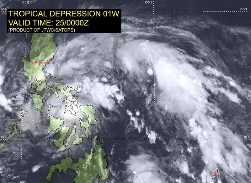
PHILIPPINES: ‘Aghon’ landfall over Ticao Island seen, may intensify into typhoon — PAGASA

The state weather bureau last observed “Aghon” over the coastal waters of San Vicente, Northern Samar today as it maintained its strength.
MANILA, Philippines — Tropical Depression Aghon is projected to make landfall over Ticao Island by Saturday evening, with PAGASA anticipating its escalation into a typhoon within the next three days.
The state weather bureau last observed Aghon over the coastal waters of San Vicente, Northern Samar on Saturday as it maintained its strength.
- Strength: 55 kilometers per hour near the center
- Gustiness: up to 85 kph
- Direction: northwestward
- Movement: 30 kph
“AGHON is forecast to move generally northwestward and may possibly make landfall over Ticao Island within the next 12 hours,” said PAGASA in a statement before Saturday noon.
“AGHON will then continue to move northwestward over the coastal waters of Burias Island between this afternoon or evening.”
Tropical Cyclone Wind Signals (TCWS) are in effect in various areas, bringing significant rainfall and strong winds.
Signal No. 1
Luzon
- eastern portion of Bulacan (Norzagaray, Doña Remedios Trinidad, City of San Jose del Monte)
- eastern portion of Nueva Ecija (General Tinio, Gabaldon)
- Aurora
- northern and southeastern portion of Quezon (Calauag, Guinayangan, Lopez, Buenavista, Catanauan, Mulanay, San Narciso, San Francisco, San Andres, Tagkawayan, Gumaca, Quezon, Alabat, Perez, Plaridel, Pitogo, Macalelon, General Luna, Atimonan, Unisan, Mauban, Real, Infanta, General Nakar, Padre Burgos, Agdangan, Sampaloc, Lucban, City of Tayabas, Pagbilao, Lucena City) including Pollilo Islands
- eastern portion of Laguna (Majayjay, Magdalena, Pagsanjan, Santa Cruz, Luisiana, Cavinti, Lumban, Kalayaan, Paete, Pangil, Siniloan, Mabitac, Santa Maria, Famy, Pakil)
- eastern portion of Rizal (City of Antipolo, Rodriguez, Tanay, Baras, Jala-Jala, Pililla, Morong, Teresa, San Mateo)
- eastern portion of Romblon (Cajidiocan, Magdiwang, San Fernando, Romblon, Corcuera, Banton)
- Marinduque
- Sorsogon
- Albay
- Catanduanes
- Camarines Sur
- Camarines Norte
- Masbate including Ticao and Burias Islands
Visayas
- Northern Samar
- Samar
- Eastern Samar (Can-Avid, Maslog, City of Borongan, San Policarpo, Taft, Llorente, Maydolong, Dolores, Jipapad, Oras, Arteche, Balangkayan, Sulat, San Julian, Lawaan, Balangiga, General Macarthur, Giporlos, Quinapondan, Hernani)
- Biliran
- northern portion of Leyte (Tunga, Pastrana, San Miguel, Matag-Ob, Tolosa, Palo, Calubian, Leyte, Carigara, Babatngon, Dagami, Jaro, San Isidro, Santa Fe, Villaba, Palompon, Tabontabon, Tanauan, Merida, Ormoc City, Isabel, Capoocan, Alangalang, Tabango, Tacloban City, Kananga, Barugo)
- extreme northern portion of Cebu (San Remigio, Tabogon, City of Bogo, Medellin, Daanbantayan, Borbon) including Bantayan Islands
Minimal to minor impacts from strong winds are seen within due to TCWS No. 1.
However, Signal No. 2 may be hoisted during the passage of Tropical Depression Aghon within the Philippine Area of Responsibility (PAR).
The following are the forecast accumulated rainfall from Saturday to Sunday noon:
- 100-200 mm: Bicol Region, Northern Samar, and the northern portion of Samar
- 50-100 mm: Eastern portion of Isabela, Aurora, Quezon including Polillo Islands, Marinduque, Romblon, the rest of Samar, Eastern Samar, Biliran, the northern portions of Western Visayas, Leyte, and Cebu
According to PAGASA, rainfall will be generally higher in elevated or mountainous areas. Because of this, flooding and rain-induced landslides are possible especially in areas that are highly or very highly susceptible to these hazards.
A typhoon by Tuesday?
Tropical Depression Aghon is forecast to emerge either over Lamon Bay or the waters north of the Camarines provinces by Sunday morning.
After which, the cyclone may make another landfall in the vicinity of Polilo Islands aand reach tropical storm category.
“Around tomorrow afternoon or evening, Aghon will begin to recurve towards the northeast,” PAGASA explains.
“As it moves over the Philippine Sea, the tropical cyclone is forecast to continuously intensify and may reach typhoon category on Tuesday evening or Wednesday morning. On the track forecast, Aghon may exit the PAR region no earlier than Tuesday.”


@[email protected]


