
ASEAN WEATHER: MANILA, Philippines- Super Typhoon Rolly made a second landfall in the vicinity of Tiwi, Albay at 7:20 a.m. Sunday and moving in the direction of Viet Nam
Super Typhoon Rolly makes 2nd landfall in Albay; Signal No. 4 in Metro Manila
By: Consuelo Marquez – Reporter / @ConsINQINQUIRER.net / 08:55 AM November 01, 2020
.
.’
Super Typhoon Rolly makes 2nd landfall in Albay; Signal No. 4 in Metro Manila
.
.
The update-11.1.2020
Sick Earth-Plague Day 338

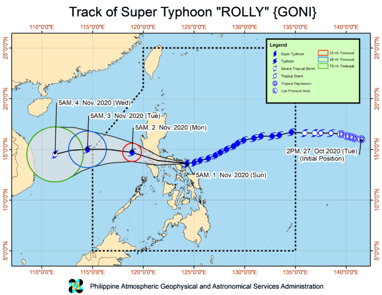
MANILA, Philippines — Super Typhoon Rolly made a second landfall in the vicinity of Tiwi, Albay at 7:20 a.m. Sunday, while Tropical Cyclone Wind Signal (TCWS) No. 5 is still up over Camarines Sur and Albay, the Philippine Atmospheric, Geophysical and Astronomical Services Administration (Pagasa) said.
‘
![]()

.
Metro Manila and other parts of the Bicol region and Southern Luzon are under Signal No. 4.
“Catastrophic violent winds and intense to torrential rainfall associated with the region of the eyewall and inner rainbands of the typhoon is prevailing or expected within the next 12 hours over Catanduanes, Camarines Norte, Camarines Sur, Albay, the northern portion of Sorsogon, Burias Island, Marinduque, the central and southern portions of Quezon, Laguna, and the eastern portion of Batangas. This is a particularly dangerous situation for these areas,” Pagasa said in its 8 a.m. wether bulletin.
As of 8 a.m., Pagasa said that the eye of the super typhoon was spotted from Daet Doppler Weather Radar in the vicinity of Tiwi, Albay.
Pagasa also reported that Super Typhoon Rolly still packs maximum sustained winds of 225 kilometers per hour (kph) near the center and gustiness of up to 310 kph while moving west southwest at 25 kph.
It made its first landfall in the vicinity of Bato, Catanduanes early Sunday morning.
![]()
.
Areas under Signal No. 4:
(A very intense typhoon will affect the locality. Winds of greater than 171 km/h up to 220 km/h may be expected in at least 12 hours.)
Luzon
Catanduanes
Camarines Norte
northern portion of Sorsogon (Donsol, Pilar, Castilla, Sorsogon City, Prieto Diaz, Gubat, Barcelona, Juban, Casiguran, Magallanes)
Burias Island
central and southern portions of Quezon (Real, Mauban, Perez, Alabat, Quezon, Calauag, Tagkawayan, Guinayangan, San Antonio, Tiaong, Dolores, Candelaria, Sariaya, Tayabas City, Sampaloc, Lucban, Lucena City, Pagbilao, Atimonan, Padre Burgos, Agdangan, Unisan, Plaridel, Gumaca, Lopez, Buenavista, San Narciso, San Andres, San Francisco, Mulanay, Catanauan, General Luna, Macalelon, Pitogo)
central and southern portions of Rizal (Tanay, Antipolo City, San Mateo, Cainta, Taytay, Binangonan, Teresa, Morong, Cardona, Baras, Jala-Jala, Pililla, Angono)
Batangas
Cavite
Metro Manila
Laguna
Marinduque
northern portion of Romblon (Concepcion, Corcuera, Banton), the northern portion of Occidental Mindoro (Abra de Ilog)
northern portion of Oriental Mindoro (Puerto Galera, San Teodoro, Baco, Calapan City, Naujan, Pola, Victoria, Socorro, Pinamalayan)
![]()
.
.
Areas are under Signal No. 3:
Luzon
rest of Sorsogon
northern portion of Masbate (Mobo, Masbate City, Milagros, Uson, Baleno, Aroroy, Mandaon) including Ticao Island
rest of Quezon including Polillo Island
rest of Rizal
Bulacan
Pampanga
Bataan
southern portion of Zambales (San Marcelino, San Felipe, Olongapo City, Subic, Castillejos, San Antonio, San Narciso, Botolan, Cabangan)
central portion of Romblon (Calatrava, San Andres, San Agustin, Romblon, Magdiwang, San Fernando, Cajidiocan)
central portion of Occidental Mindoro (Sablayan, Mamburao, Santa Cruz, Paluan) including Lubang Island
central portion of Oriental Mindoro (Gloria, Bansud, Bongabong)
Visayas
Northern Samar
.
![]()
.
Areas under Signal No. 2:
Luzon
Aurora
Nueva Vizcaya
Quirino
Benguet
La Union
Pangasinan
rest of Zambales
Tarlac
Nueva Ecija
rest of Oriental Mindoro
rest of Occidental Mindoro
rest of Romblon
rest of Masbate
Visayas
The northern portion of Samar (Catbalogan City, Jiabong, Motiong, Paranas, Hinabangan, San Sebastian, Tarangnan, Pagsanghan, San Jorge, San Jose de Buan, Matuguinao, Gandara, Santa Margarita, Calbayog City, Santo Nino, Almagro, Tagapul-An),
northern portion of Eastern Samar (San Julian, Sulat, Taft, Can-Avid, Dolores, Maslog, Oras, San Policarpo, Arteche, Jipapad), the extreme northern portion of Antique (Pandan, Libertad, Caluya), and the northwestern portion of Aklan (Buruanga, Malay, Nabas, Ibajay)
![]()
.
.
Areas under Signal No. 1:
Luzon
Mainland Cagayan
Isabela
Apayao
Kalinga
Mountain Province
Ifugao
Abra
Ilocos Norte
Ilocos Sur
Calamian Islands
Visayas
The rest of the northern portion of Antique (Sebaste, Culasi, Tibiao, Barbaza, Laua-An)
rest of Aklan, Capiz, n
northern portion of Iloilo (Lemery, Sara, Concepcion, San Dionisio, Batad, Estancia, Balasan, Carles)
northern portion of Cebu (San Remigio, Bogo City, Medellin, Daanbantayan) including Bantayan Islands
Biliran
rest of Samar
rest of Eastern Samar
northern portion of Leyte (San Isidro, Tabango, Villaba, Matag-Ob, Palompon, Ormoc City, Pastrana, Palo, Calubian, Leyte, Kananga, Capoocan, Carigara, Jaro, Tunga, Barugo, Alangalang, Santa Fe, Tacloban City, Babatngon, San Miguel)
Tropical Storm Atsani
.
![]()
.
Meanwhile, Tropical Storm Atsani, which was last spotted 1,205 kilometers east of southern Luzon, has re-intensified into a tropical storm but is still outside the Philippines area of responsibility (PAR).
Pagasa predicted that Atsani will likely enter Philippine territory Sunday morning and will be given a local name of Siony.
“It remains less likely to affect any portion of the country over the next 2 to 3 days. It is likely to intensify into a severe tropical storm in the next 24 to 36 hours,” Pagasa said.
Atsani is packing maximum sustained winds of 65 kph near the center and gustiness of up to 80 kph. It is moving west-northwest at 30 kph.
gsg
![]()

SIGN UP TO RECEIVE OUR EMAIL
.
The most important news of the day about the ASEAN Countries and the world in one email: [email protected]