
TRAVEL: The 50 best hikes in L.A.
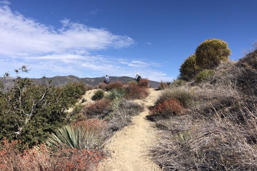
Amboy Crater

The 50 best hikes in L.A.
If Mother Nature made a to-do list for L.A., this might be it. These 50-plus hikes capture all that Southern California has to offer. Ocean views? Check. Desert drama? Check. Lung-busting, high-elevation peaks? Check and check. This list is designed to inspire, with something for novice to veteran hikers. Distance and elevation gains may vary, depending on which navigation tool you use. Some hikes require an Adventure Pass or other permits; check beforehand. Grab a map, guidebook or your favorite trail app to get started on discovering all the local outdoors has to offer.
This story is part of our ultimate guide to hiking in L.A.
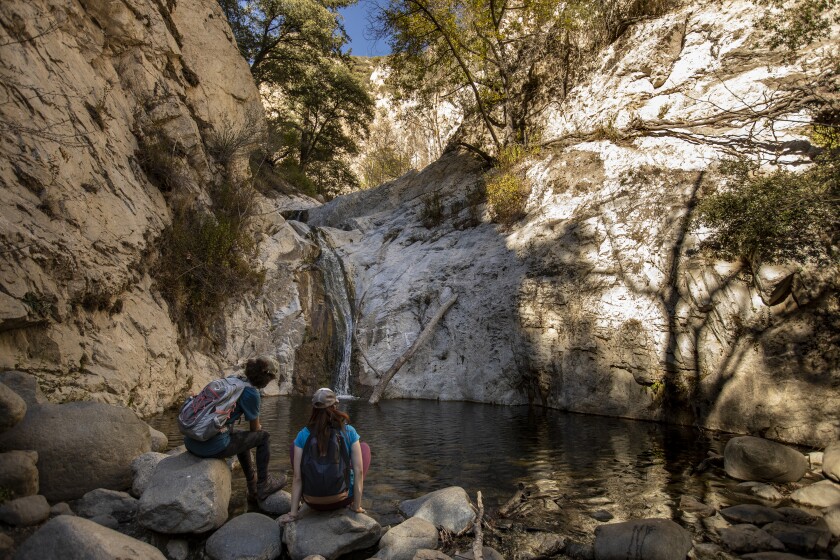
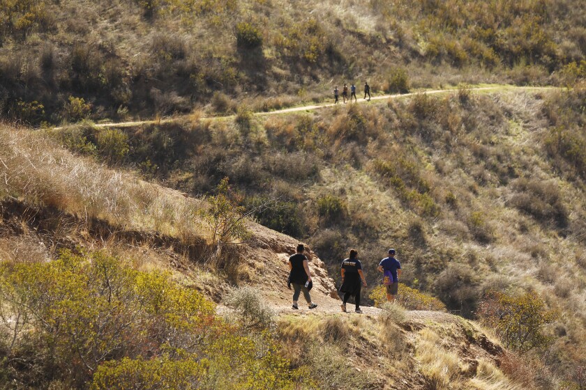
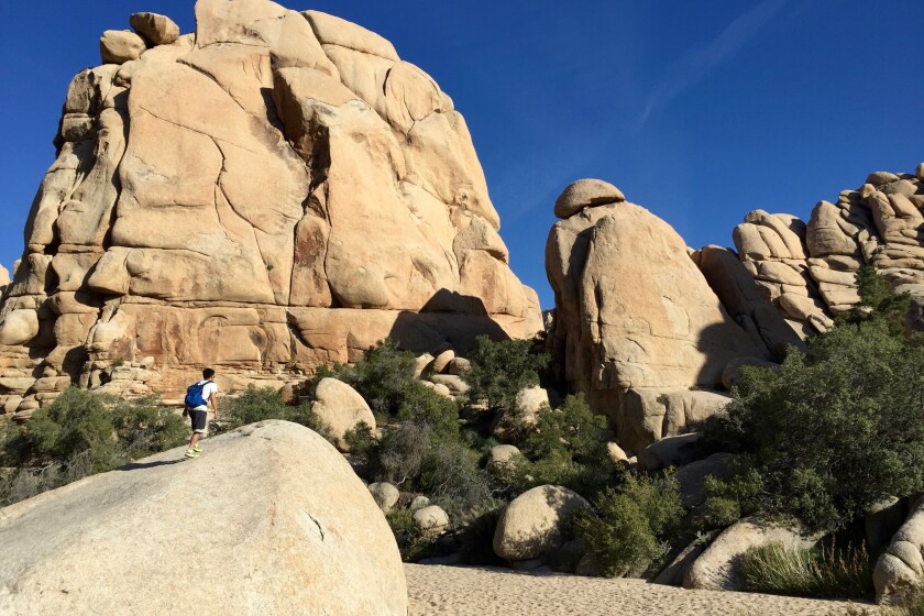
Switzer Falls
Water, water, water. It’s the most sought-after item on a Southern California hike, whether it’s bottled in your pack or streaming down a hillside in front of you. The waterfalls in the front range of the Angeles National Forest are popular (code for “expect big crowds, especially on hot weekends”), but that’s no reason to avoid them. The site was one of the first mountain resorts to open to “tourist hikers” in 1884, and it’s easy to see why. The downhill hike drops you to the top of the falls and then into cool Bear Canyon. Refresh yourself at the 50-foot lower falls and maybe take a swim in its pool (the upper falls are hard to access on a sketchy route). Hang out by the water or in one of the shady picnic areas along the way. The way out is the same — only uphill. Go early to snag a parking spot and beat the hordes.
Park and start at the Switzer Picnic Area on the Angeles Crest Highway about 10 miles north of La Cañada Flintridge. Directions to trailhead.
![]()
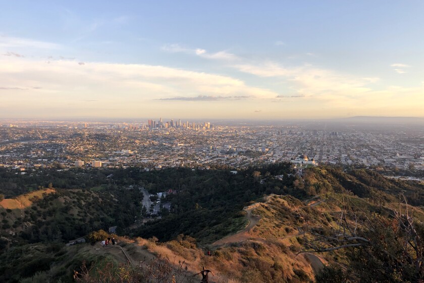
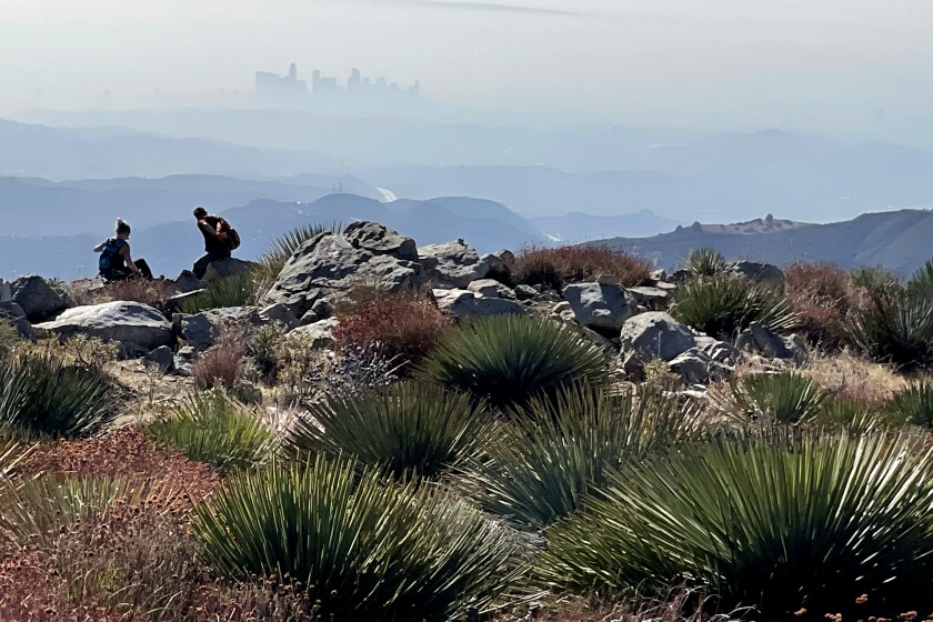
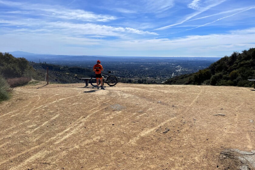
Mt. Hollywood
You can’t call yourself a Los Angeles hiker without a trek to this Griffith Park peak. Views from the top start at Griffith Observatory below and then sweep west from downtown L.A. to Hollywood, Century City and the ocean, when there’s no haze or fog. At night, the panorama changes to a carpet of twinkling lights. Griffith J. Griffith donated the land to the city in 1896 as “a resort for the rank and file, for the plain people.” There are shorter routes to this peak, but the trail from the park’s merry-go-round parking lot maxes out on views and parking.
Park and start at the merry-go-round parking lot/Old Zoo in Griffith Park. Directions to trailhead.
![]()
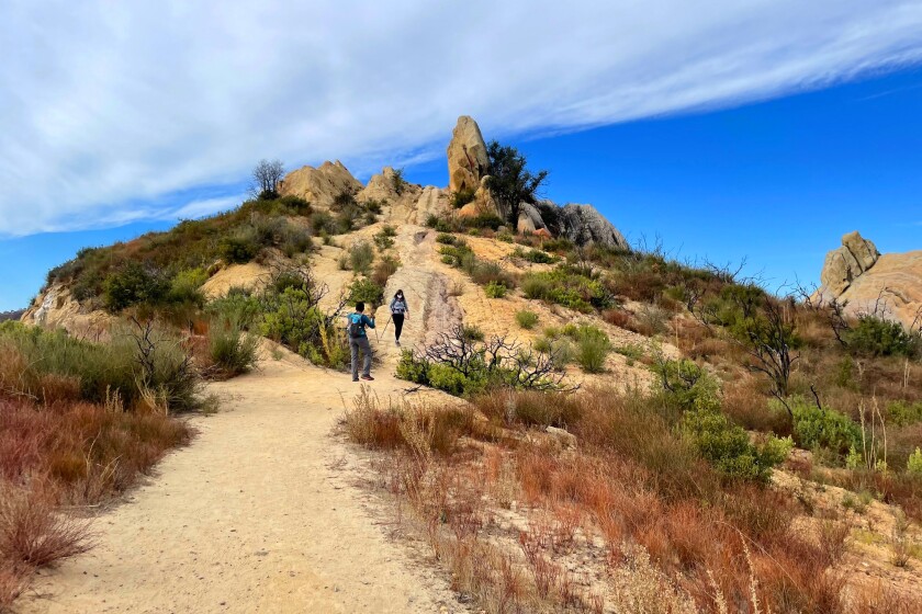
Hoyt Mountain
Hoyt, just 11 miles north of La Cañada-Flintridge, is one of the close-to-home front-range peaks in the Angeles National Forest that is easily overlooked. The broad, flat summit has vertical rock slabs that frame views of distant downtown Los Angeles. At less than 5,000 feet in elevation, it’s seems as if it should be an easy climb. Don’t be fooled. The goat trail to the top makes this a serious workout, and a few false summits will keep you sucking in air to the end. Start on an easy canyon trail from Clear Creek Junction and make a loop on the return route through a picnic area dense with pine trees.
Park in the lot and start at the Clear Creek Visitor Information Center (which is closed because of COVID-19) on the Angeles Crest Highway. Directions to trailhead.
![]()
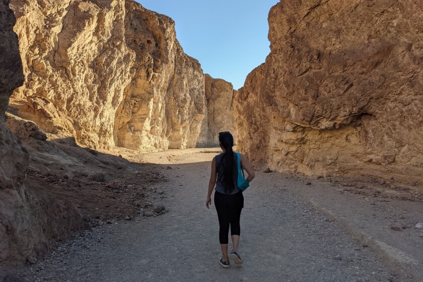
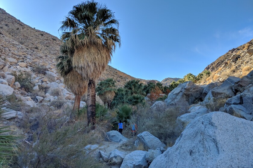
Zabriskie Point/Golden Canyon/Gower Gulch Loop
Looking for an awe-inspiring hike in Death Valley? The highly rewarding trek from famous Zabriskie Point combines Golden Canyon and Gower Gulch loop trails for a showstopping workout. The panoramic lookout, named after the manager of the Pacific Coast Borax Co. (partly responsible for increased tourism here),offers jaw-dropping vistas of the golden-brown hills below as well as the salt flats and Panamint Mountains beyond. Few hikers go farther than the paved overlook, but those who descend into the slot canyons of the badlands are rewarded with close-ups of Manly Beacon, Red Cathedral and other prominent rock features. The hike back up is tough but make it your turning point, not your breaking point, as you complete your ascent through the dry gorge.
Park in paved lot, start five miles southeast of Furnace Creek in Death Valley National Park. Directions to trailhead.
![]()
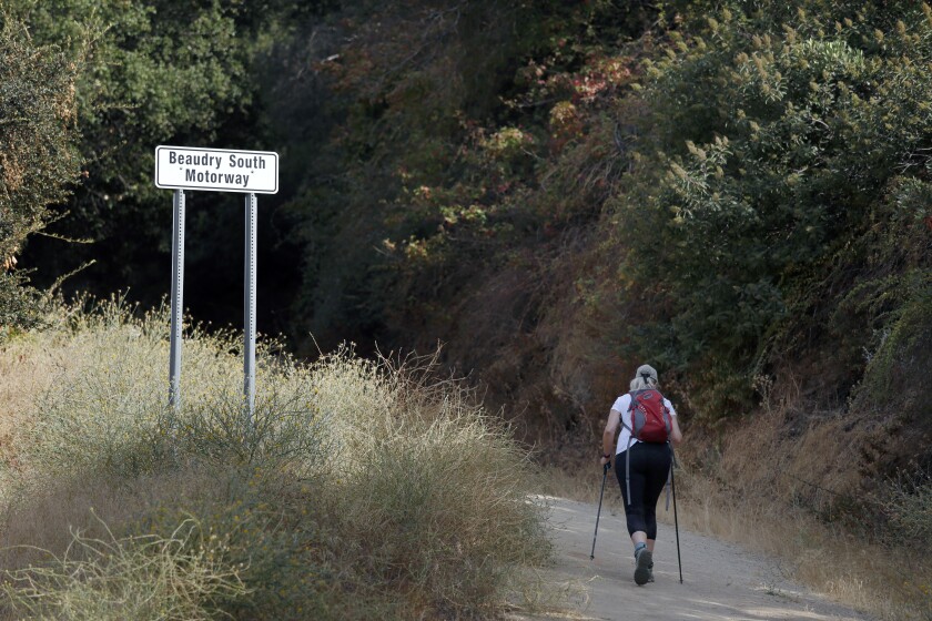
Beaudry Loop
Don’t be put off by the cushy Glendale neighborhood at the trailhead. Soon you’re climbing up fire roads in the Verdugo Mountains that get your heart pumping. The trail slowly reveals views of more of the mountain range between Glendale and Burbank and the neighborhoods that sprang up below. At the intersection with a north and south loop, go either way to 2,656-foot Tongva Peak, named for the Native Americans who thrived in the local mountains. Take a break at the top and marvel at how wild this spot feels despite the urban clutter below. Complete the loop and you’re done.
Park on the road and start at Beaudry Boulevard off Country Club Drive in Glendale. Directions to trailhead.
![]()
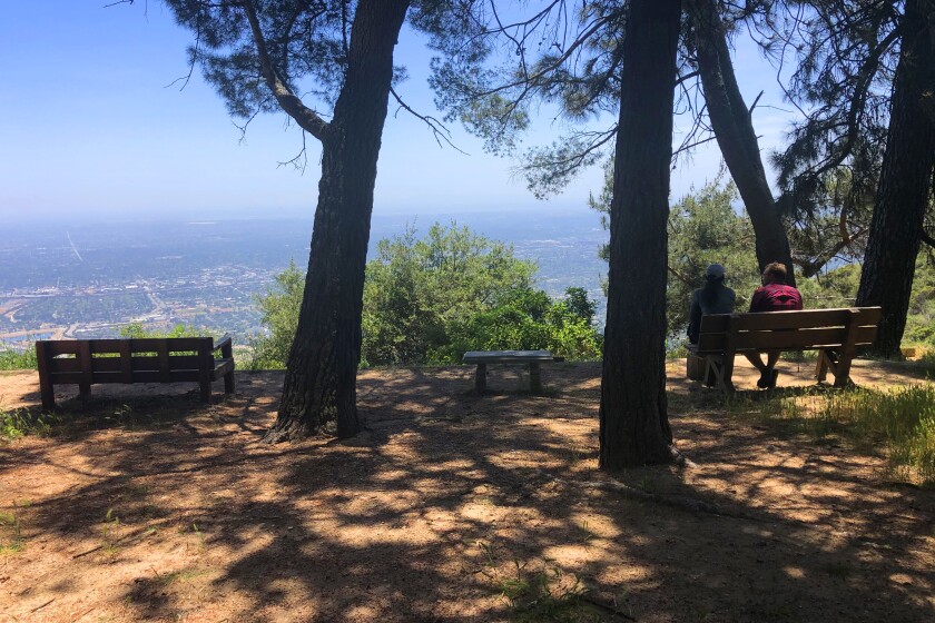
Henninger Flats
There’s nothing but shade and trees on this ridge high above Altadena. The pop-up tree nursery that started here more than a century ago still raises baby trees used to replant the forest after fires and other catastrophes. The route up follows an exposed, steep fire road before arriving at benches and picnic tables amid tall pines, cedars and firs. There’s overnight camping, a 1925-era fire lookout that was moved from the Santa Monica Mountains to this site and a visitor center that’s usually open in non-pandemic times.
Park and start at Eaton Canyon Nature Center in Pasadena (reservations required). Directions to trailhead.
![]()
Solstice Canyon
The shady Malibu canyon takes you mental miles from the city and provides a sweet introduction to the Santa Monica Mountains. The hike gets high marks for a small waterfall (which may or may not be flowing) and the ruins of Roberts Ranch, which belonged to the successful grocery-chain operator Fred Roberts. The brick fireplace, foundation and other fragments of the midcentury home remain. It was designed in 1952 by Black architect Paul Revere Williams, who had designed much of the remodeled Beverly Hills Hotel. Start up the Rising Sun Trail that winds through sycamores, oaks and alders, walk the loop at the top and then descend on the main road.
Park and start at Solstice Canyon park entrance in Malibu. Directions to trailhead.
![]()
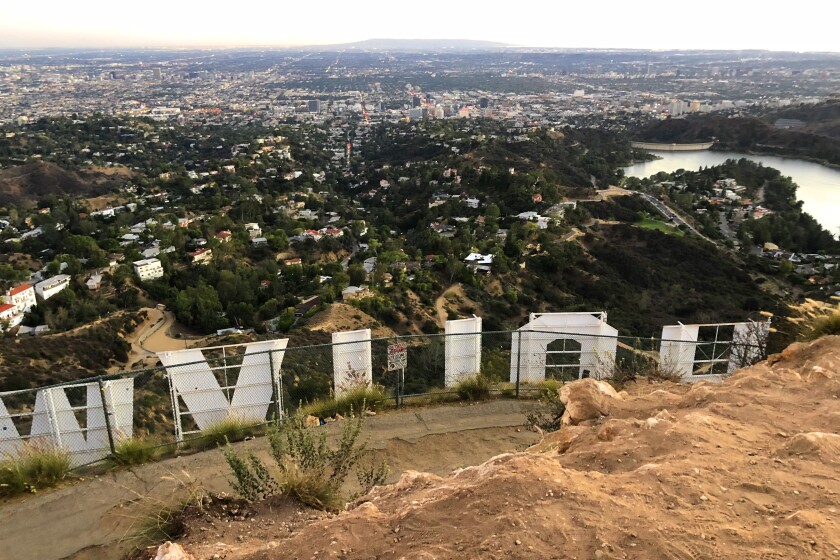
Mt. Lee
Every visitor to L.A. you host will pester you to take them to the Hollywood sign. The best way is to go on foot in Griffith Park. Spoiler alert: It’s forbidden to touch or get close to the city’s most recognizable landmark. It’s blocked off by a chain-link fence. You can, however, hike to 1,709-foot Mt. Lee where you’ll be above and behind the sign. The 50-foot letters stand like sentinels on the hillside, a sign put up in 1923 with “land” tacked to the end to advertise a real estate development. Now hikers look down from this point at mansions surrounding the deep blue Hollywood Reservoir. (Try to ignore the 300-foot broadcast tower and complex off to the side.) There are several ways to get to the sign; Modern Hiker recommends taking the Brush Canyon Trail with an add-on to see the Bat Cave from the 1960s “Batman” TV series.
Park in a lot and start at Brush Canyon/Canyon Drive West in Griffith Park. Directions to trailhead.
![]()
Nicholas Flat
You need a good reason to turn your back on a Malibu beach. This hike may be it. The Nicholas Flat trail starts at Leo Carrillo State Park and travels inland and uphill to a ridge in the Santa Monica Mountains. The terrain and the views make this one of the best coastal hikes around; savor the views as you take breaks along the way. The “flat” part of the hike leads to grassy meadows, a pond you can loop around and stands of live oaks. Stay awhile and explore before heading back to the beach. Look for coreopsis, big shaggy yellow flowers, that dot the hillsides in early spring.
Park at Leo Carrillo State Park in Malibu and start from there. Directions to trailhead.
![]()
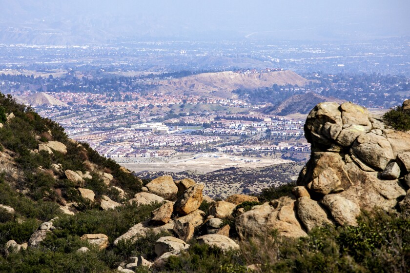
Rocky Peak
This Simi Valley hike isn’t on the radar of many hikers. It should be. Locals know these hills as the place where pioneers set up ranch life in the early 19th century. It’s easy to conjure the Old West as you hike amid dramatic rock slabs and grassy hillsides that are brown in summer, green in spring. The small 2,717-foot peak lives up to its name; it’s just a few slabs that are hard to find and hard to get to. Look for a running trail and scramble a bit for views that put you at eye level with turkey vultures riding thermals in lazy loops. Take this hike on a cool day; you’ll hate yourself if you go in summer. “No shade ever,”states one trail app. Spend some time looking for the grooves of covered-wagon wheels etched in the rocks beneath your feet.
Park and start at the Chumash Trail on Flanagan Drive in Simi Valley. Directions to trailhead.
![]()
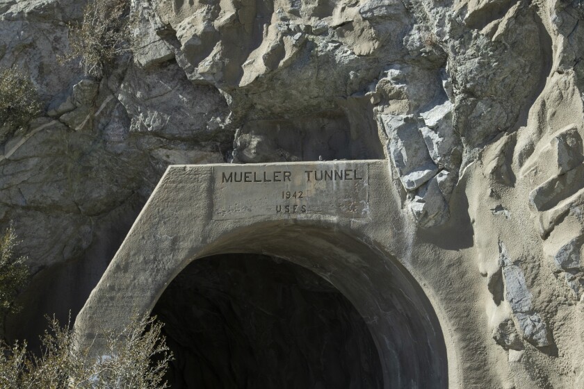
Eaton Saddle
It’s time for peakomania! The saddle off Mt. Wilson Road in the Angeles National Forest is a stepping-off point to four peaks, which you can do in a day. It’s a good uphill workout if you haven’t been hiking in a while. Don’t be misled by the low mileage; the ups and downs keep this route challenging and filled with panoramas of L.A. and beyond. From the trailhead, walk a half-mile through a tunnel. The first peak is Mt. Markham (5,729 feet), a hulking mass with a trail that climbs a steep, rocky spine. Then take out-and-back routes to bag Mt. Disappointment (5,968 feet), which has radio towers on top; the prettier San Gabriel Peak (6,161 feet); and Mt. Lowe (5,574), the farthest away.
Park and start at Eaton Saddle near Red Box, about seven miles north of La Cañada Flintridge on Angeles Crest Highway (California 2). Directions to trailhead.
![]()
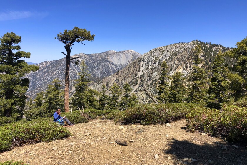
Strawberry Peak
Hikers supposedly named the peak for its shape, an upside-down strawberry. At 6,142 feet, it’s the high spot in the front range of the San Gabriel Mountains, barely nosing out San Gabriel Peak. The trail starts gently and then comes to a long saddle. The goat trail on the left starts steeply down before heading upward, at times on slippery loose dirt and scree. You’ll come to what you think is the top but it’s a false summit. Press on. Eventually, you’ll arrive at the rocky top and a chance to pause and enjoy the well-earned views of the Arroyo Seco and Big Tujunga watersheds.
Start at Red Box, almost seven miles north of La Cañada Flintridge on Angeles Crest Highway (California 2). Directions to trailhead.
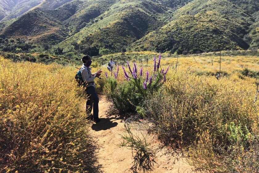
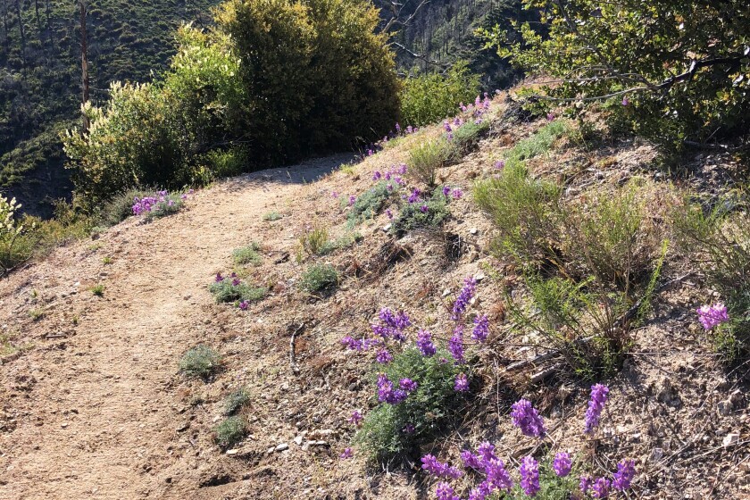
Mt. Josephine
Let this peak be your gateway to the 700,000-acre Angeles National Forest. The most scenic route starts at Colby Canyon, which winds past a small creek (when there’s water) with big rock walls. The climb continues on a narrow trail that switchbacks up the canyon. Soak up the views and the terrain before continuing past Douglas firs and pines that add a big forest feel. Three lime-green shelves stand at the 5,558-foot summit, remnants of a fire tower that burned in 1976. Visitors seem compelled to place rocks and keepsakes on the shelves.
Park at a pullout and start on the trail at Angeles Crest Highway (California 2), 10 miles north of La Cañada Flintridge. Directions to trailhead.
![]()
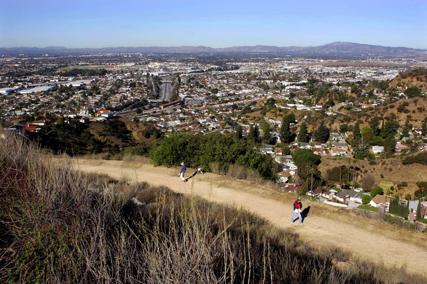
Mt. Lukens
To experience L.A.’s highest and lowest points, dip your toe in the Pacific then hike to the 5,066-foot summit of Mt. Lukens. It’s barely within city limits, but it counts as the top of the city. (By comparison, the Wilshire Grand skyscraper in downtown L.A. rises just 1,100 feet.) The peak doesn’t impress; it hosts several communications towers, some that hum noisily. It’s the journey and the views that make Lukens worthwhile . The most popular routes start at George Deukmejian Wilderness Park in Glendale, where buckwheat, paintbrush and monkeyflowers bloom in spring. The harder trail winds up quieter, shaded Stone Canyon; you may not see another soul all day.
Park on the road and start at the Wildwood Picnic Area, 3299 Big Tujunga Canyon Road, Tujunga. Directions to trailhead.
![]()
Hidden Pond/Coyote Trail
The hike takes you to the lonely northwest corner of Point Mugu State Park. The vernal pond is elusive; it may not appear even after heavy rains. When it does, ducks and red-winged blackbirds can be seen amid the tall grasses on the perimeter. Even without water, the pond’s wide, shallow meadow makes a nice rest stop. Keep going on the Coyote Trail, which rolls up and down through greened-up hillsides dotted with shrubs charred by previous fires. This hike puts you in the heart of the Santa Monica Mountains, reaching a few high points that offer ocean views of Malibu and the Oxnard Plain.
Park in lot, start at Rancho Sierra Vista/Satwiwa on Sycamore Canyon Road. Coyote Trail adds 2.2 miles and less than 1,000 feet of gain. Directions to trailhead.
![]()
Inspiration Point
It’s a big boast to claim the name Inspiration Point. The wooden shelter with picnic benches on a flat stretch in the San Gabriels above Altadena proclaims the title with a huge sign. There is also a slew of metal spotting scopes labeled “Locating Redondo Beach,” “Locating the Rose Bowl” and so on, pointed at landmarks and destinations around Southern California. On a clear day, you might see the ocean and Santa Catalina; under thick fog, you’ll be lucky to find the trail down. The trail climbs 2½ miles to Echo Mountain, the site of a one-time resort hotel and railway that welcomed visitors during L.A.’s great hiking era (1880s to the 1930s). Only ruins are left. From there, make a loop by going up the Sam Merrill Trail and down the steep but beautiful Castle Canyon. Inspiring? Sometimes, and a good workout too.
Park on the street, start at the end of Lake Avenue in Altadena. Directions to trailhead.
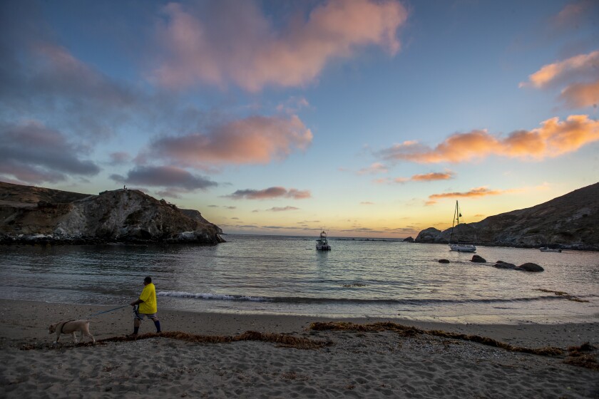
Little Harbor
L.A. is lucky to have Santa Catalina just an hour away. Hiking has exploded since 2009 when the Trans-Catalina Island Trail opened, a rugged 38-mile east-west route across the island. One of the prettiest segments starts at Two Harbors on the island’s quieter side and winds on fire roads and trails to a beach at Little Harbor. Relax before retracing your steps, then treat yourself to a meal at Harbor Reef Restaurant. Check hiking rules and permits at catalinaconservancy.org.
Start and end at Two Harbors. Directions to trailhead.
![]()
Mt. Pacifico
The hike follows the Pacific Crest Trail on one of its less traveled segments in Southern California. In early spring, look for fast-moving thru-hikers doing the entire 2,650-mile journey from Mexico to Canada. The route that begins in the Sunland area winds uphill to a flat ridge and, as you move higher, to pine-covered hillsides. In spring, you’ll find wildflowers and bright red snow plants that pop up after the melt. A short, steep, calf-burning trail leads straight to the summit. On top, you’ll see a ring of boulders — plus a campground, picnic tables and a bathroom — and expansive panoramas of the San Gabriels as well as the desert-flat Antelope Valley and Little Rock below.
Start at Mill Creek Summit Picnic Area off Angeles Forest Highway. Directions to trailhead.
![]()
Verdugo Mountains Traverse
The one-way route crosses the lesser-known Verdugo Mountains in the northeast end of the San Fernando Valley. Views are good all along the trail, which takes the sting out of hiking on wide dirt roads that start and end in residential neighborhoods. It follows three named “motorways” — Chandler, Verdugo and Las Flores — and passes Verdugo and Tongva peaks. You can cross the range many different ways; AllTrails has a good route, starting in Sun Valley and ending in Glendale, that’s easy to follow. Don’t forget to leave a car at the endpoint.
Park on the street and start on Olive Terrace Trail in Sun Valley. Directions to trailhead.
![]()
Bulldog Loop Trail
Get ready for a tough, long hike in the Santa Monica Mountains that starts inland and circles out to lofty ocean views. The best part of the trail follows the 67½-mile Backbone Trail high above the coast to Corral Canyon, where massive sandstone slabs impress. More impressive: They were formed in the ocean during ancient times, which is hard to believe as you look down on the distant water. The hike follows the wide, dirt Bulldog Motorway, which feels like an endless climb, before swinging out toward the ocean and back inland. Along the way, look for man-made Century Lake, the filming site of the 1970s-’80s TV show “MASH,” a meditation circle made from small rocks and oak-filled Tapia Park. Take care on the short walk on Las Virgenes Road before rejoining the trail.
$12 to park, start at Malibu Creek State Park in Calabasas. Directions to trailhead.
![]()
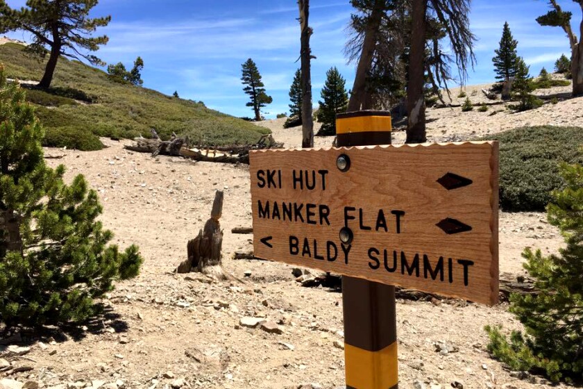
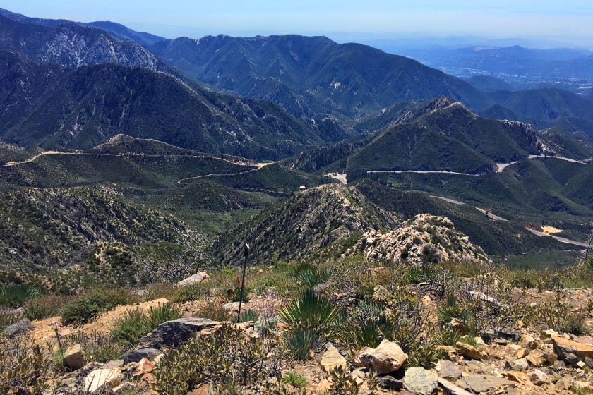
Mt. Baldy
This jewel of Southern California has a classier name: Mt. San Antonio. Baldy is just its nickname, probably because of its treeless flanks. The highest point in L.A. County soars above Claremont and offers the best hard training around. Need elevation? Baldy sits at 10,069 feet Need aerobic conditioning? One route rises 1,000 feet per mile. Need comfort? Stop for a beer or a burger at Top of the Notch, a slope-side restaurant that hums with skiers in winter and mountain cyclists and hikers in summer. But first you must bag the peak. Start up the wide fire road to the restaurant and continue uphill where the path narrows to one-way foot traffic on the Devil’s Backbone. At the top, views are epic in all directions; retrace your steps to return. Once you’ve mastered this hike, take on longer and steeper routes. But first, catch your breath.
Park at the trailhead; start at Manker Flat near Mt. Baldy Village. Directions to trailhead.
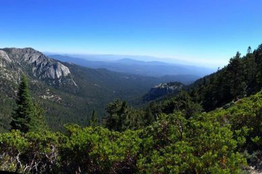
Mt. San Jacinto
Prepare for One Serious Hike. Of the three highest peaks in SoCal, this one may have the most beautiful trails, particularly the tough route that climbs more than 4,500 feet to the top. The Marion Mountain Trail starts in Idyllwild and continues upward through shaded forest, then opens up to boulders, then water seeps where columbines and cow lilies bloom. When you close in on the 10,834-foot peak, look for a stone hut stocked with emergency supplies; feel free to wander in and have a look. Now you’re close. You may have to wait your turn for a shot at the scramble to the small rock summit. Yep, it gets that busy.
Start at Marion Mountain Trail in Idyllwild. Directions to trailhead.
![]()
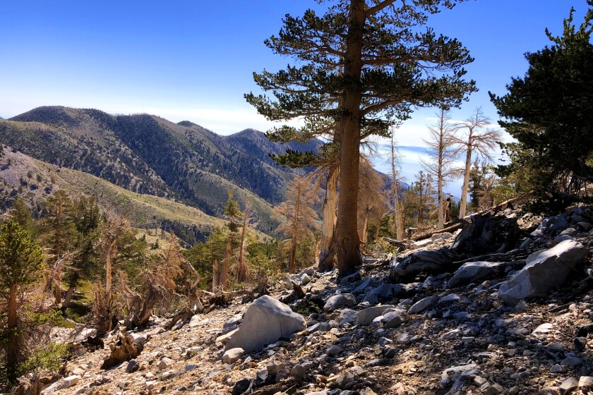
Mt. San Gorgonio
San G tops out at 11,499 feet in elevation, the tallest in Southern California, and is located in the San Bernardino National Forest. It’s a desirable peak, but recent wildfires have not been kind to the mountain. The trail from South Fork to the top burned five years ago and still shows charred trees and other signs of fire damage. The El Dorado fire swept through last year and has keep the wilderness area closed ever since. It might open in time for summer hiking. The long, winding way starts at South Fork and a pretty meadow and a (sometimes) lake before emerging from the trees for the exposed push to the top. The last mile or so may exhaust you; stop and savor the rugged beauty and your accomplishment.
Take the South Fork Trail to Dollar Lake and on to the peak. Directions to trailhead.
![]()
Fox Mountain
Prepare for a long, rolling hike through some of the nicest scenery in the Tujunga area. The trail rises through chaparral scrub and weaves through a canyon that surprises with ferns and a small, seasonal creek. It rolls along the flanks of mountains until you come to a flat saddle. The summit is to the right, about 500 feet up a short vertical stretch. Look for large yucca that bloom until late spring.
Start at Big Tujunga Canyon Road near Vogel Flats in Tujunga. Directions to trailhead.
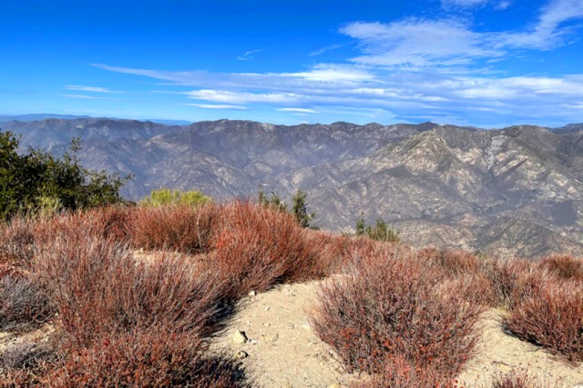
Mt. Wilson
You could drive to the historic observatory above Sierra Madre, but there’s no glory in that. Keep this high point on your list for the workout, the challenge and the history. Start on the Mt. Wilson Trail in Sierra Madre, where you will hear water trickling through the canyon in spring and continue along a rocky stretch to the cool and shady Old Orchard Camp; take a break at the old-timey former resort. Switchback up to the Mt. Wilson Trail and on to the top where you’ll find a picnic area, generous views of Pasadena and beyond and, if you’re lucky, the ocean. Explore the large complex on top — just remember you have to walk back down.
Park on the street and start at Mt. Wilson Trail Park in Sierra Madre. Directions to trailhead.
![]()
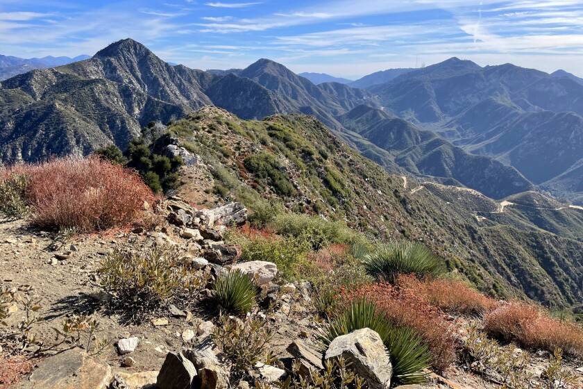
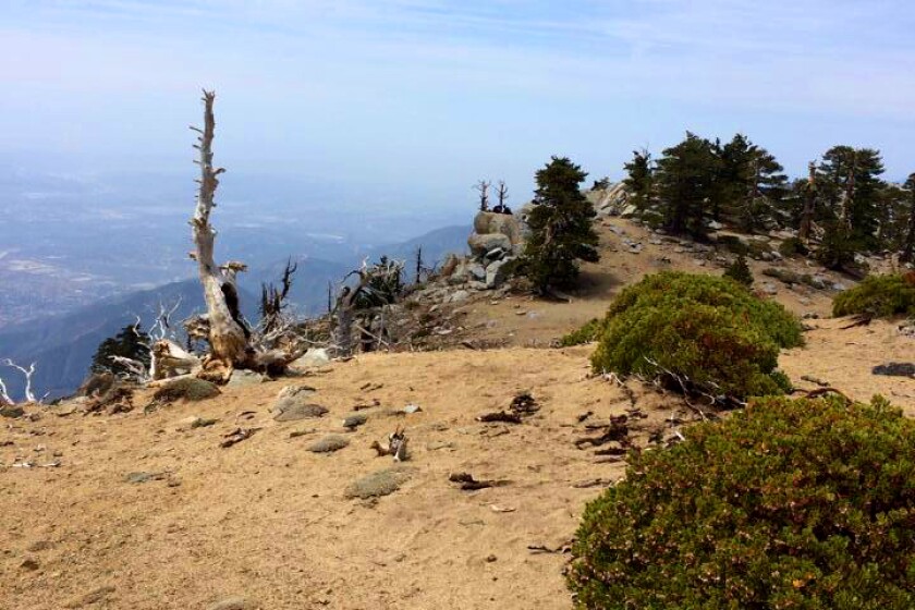
Mt. Baden-Powell
The most surprising thing atop this Angeles National Forest peak is the sturdy monument to Robert Baden-Powell, founder of the Boy Scouts. The 9,406-foot high point stands a little beyond the marker. The shortest route to the summit follows part of the Pacific Crest Trail and packs in 40 switchbacks and wide-angle views — a good place for high-elevation conditioning. There are longer ways to reach the summit (from Islip or Dawson saddles), but road and trail closures from the Bobcat fire might keep them offline for at least another year. In the meantime, enjoy the short way.
Park and start at Vincent Gap off Angeles Crest Highway (California 2). Directions to trailhead.
![]()
Ontario Peak
The route starts at Icehouse Canyon, the busy gateway to a number of peaks in the Mt. Baldy area. Ontario sometimes is overlooked, which is a good thing if you are craving uncrowded time. The hike starts with 3½ miles of switchbacks up to Icehouse Saddle, where you have a choice of routes. The sign to Ontario is well marked and will lead to a camp and meadows of downed trees that in good years have a nice show of wildflowers. A short, steep pitch takes you to the small summit, which features a bottle opener mounted on a tree (just in case you need one).
Park at the Icehouse Canyon lot and start up the trail. Directions to trailhead.
![]()
Cucamonga Peak
The trail to the top follows the same Icehouse Saddle route and turns at the well-signed intersection. The rocky trail weaves along canyons before leading uphill in tight switchbacks. As you climb, pines and Bighorn Mountain come into view. It’s easy to miss the short side trail that leads to the 8,858-foot summit; miss it and you’ll wind up at Etiwanda Peak in a few miles. The top has plenty of room to spread out amid manzanita and soft sand. Permits are required.
Park at the Icehouse Canyon lot and start up the trail. Directions to trailhead.
The Three Ts
The Three Ts in the Mt. Baldy area — Thunder, Telegraph and Timber — is a point-to-point hike that will take you up and down all day starting at the base of Mt. Baldy. You’ll hit Thunder Mountain first, an exposed ski run with a lift at the top. Next comes Telegraph, which offers nice views of the surrounding San Gabriels. The best is saved for last: Timber, a sweet, quiet spot off the main trail to Icehouse Saddle. Take a well-earned break before heading down the canyon. Go with a friend and drop a car at the end point (Icehouse Canyon). You can do this hike in reverse order too.
Park at Manker Flat and start up the Mt. Baldy Trail. Directions to trailhead.
![]()
Skyline Trail
This is the most extreme hike in Southern California, sometimes called Cactus to Clouds or Palms to Pines. Complete this hike and you have bragging rights for life. The route from the desert floor in Palm Springs to the top of Mt. San Jacinto climbs more than 10,000 feet. The first part winds steeply up to Long Valley (7,900 feet) in 11 miles as the desert diminishes at every turn. No one would blame you if you stopped here and took the Palm Springs Aerial Tramway down. Those who press on add an additional five miles and 2,400 feet of gain to San Jacinto’s summit. You still have to walk back to the tram for a ride to the bottom — and figure out how to shuttle to your car.
Park on the street; trail starts behind the Palm Springs Art Museum. Directions to trailhead.

Park to Playa Trail
Urban trails help us navigate Los Angeles in new ways. Put the Park to Playa Trail on your to-do list. Parts of the 13-mile route have been open for years, but it wasn’t until November that it was completed. Good views of L.A. are guaranteed on the dirt-and-paved route from Baldwin Hills to Playa del Rey. Enjoy side trips in Kenneth Hahn State Recreation Area (the MLK Memorial has great views of L.A.), Stoneview Nature Center, the Baldwin Hills Scenic Overlook and the Ballona Creek Bike Path that will keep you going in the right direction. Set up a car shuttle, call a ride-share or use public transit to return to the start.
Park or take transit to the start at the Stocker Corridor Trail in the Baldwin Hills area. Directions in trailhead.
![]()
Harmon Canyon Preserve
Ventura welcomed its first nature preserve with a trail network that takes you to groves of native oak trees, along streams and up to high points for vistas of the surrounding mountains and the Channel Islands. Being here feels as if you’re taking a trip through Old California. You can piece together routes on the 10 miles of trails in the preserve; even a short 2½-mile trek takes you uphill to savor views of the coast.
Park at the trailhead off McVittie Place in Ventura. Directions to trailhead.
![]()
Long Canyon Trail
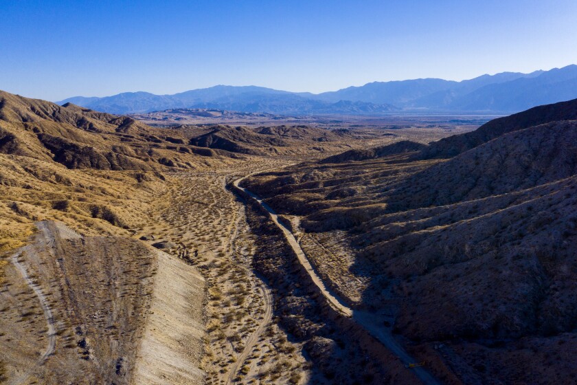
Desert lovers take note: A new route that connects Desert Hot Springs and Joshua Tree National Park is set to open in fall. It’s part of a trail network created by the Coachella Valley Mountains Conservancy and Friends of the Desert Mountains (which also created the next two trails). Parts of the Long Canyon route are already in use; this trail connects the dots for 12 miles with signs to keep hikers on track. “You get great vistas of the Coachella Valley,” executive director Jim R. Karpiak said. “It’s a beautiful landscape, a mix of pure desert and woodlands in the higher desert.”
You may need to set up a car shuttle to complete the point-to-point trek. Check with the conservancy at cvmc.ca.gov to find out when this trail comes online. Directions to trailhead.
![]()
Indio Hills Badlands Trail
Seashells and beach sand in the desert? You’ll find both on the recently opened trail in Indio, remnants of ancient Lake Cahuilla that once covered the area. The AllTrails app describes the loop’s landscape as “twisted and tortured rocks that have been uplifted and moved over millions of years.” Creosote bushes and tilted sedimentary slabs, including a skull-like rock formation, keep things interesting.
Park and start at Golf Center Parkway in Indio. Directions to trailhead.
Kim Nicol Trail
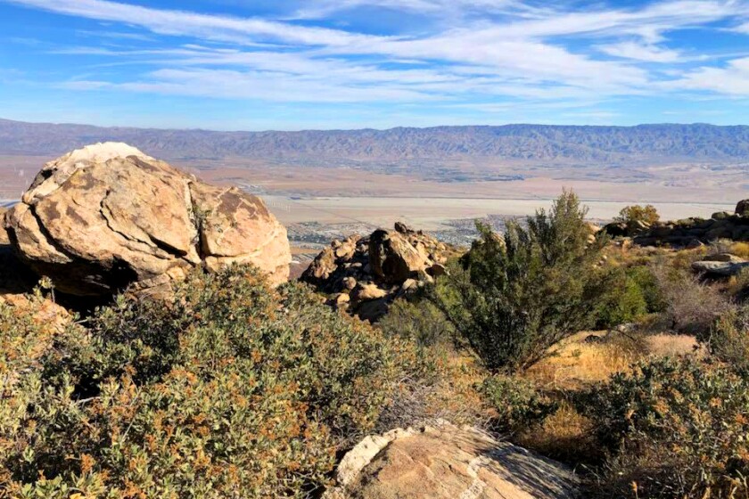
Prepare to get sand in your boots on this all-desert loop that opened in 2018. Dunes and sedimentary formations provide clues to how erosion and uplift formed the rugged landscape that unfolds before you near Desert Hot Springs. A high point on the trail offers 360-degree views of the valley and San Jacinto and San Gorgonio peaks. Look for endangered Coachella Valley fringe-toed lizards during a spring visit. Just don’t go on a 115-degree day.
Park and start at 20th Avenue and Corkill Road in unincorporated Desert Edge, east of Desert Hot Springs. Directions to trailhead.
![]()
Wisdom Tree
The up-and-coming landmark is a 15-minute walk from the Hollywood sign and goes by various names: the Wisdom Tree, Wishing Tree, Giving Tree, Magic Tree, you get the idea. Everyone seems to have a name for the lone, scraggly pine tree that’s being loved to death near Cahuenga Peak in Griffith Park. Sometimes it’s decorated with a few mementos, sometimes it’s honored with a box (containers change from time to time) at its feet that holds notes and journals from people who have something to tell the tree. Although the route to the Hollywood sign remains open, the narrow trail to the tree is closed because of COVID-19. Don’t worry; it’ll be back, along with Angelenos and their post-pandemic hopes and wishes.
When the trail reopens, try the 3-mile round-trip route, less than 1,000 feet of gain, that starts at paved Wonder View Drive near Lake Hollywood Reservoir. Directions to trailhead.
![]()
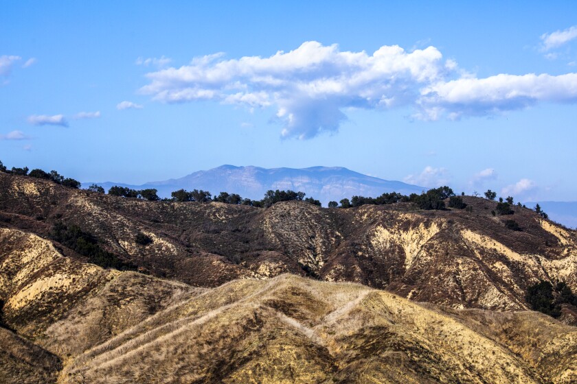
Brown Mountain
It’s unusual that a SoCal mountain has a link to abolitionist John Brown. Owen Brown, who fought alongside his abolitionist father at the failed 1859 anti-slavery rebellion in Harpers Ferry, W.Va., joined his brother, Jason, to live in hilly Altadena Meadows. “After building a cabin in El Prieto Canyon, the Brown brothers began to blaze a trail to the summit of Brown Mountain, named for their father,” said an earlier L.A. Times story. Walk a lovely loop — up the wooded canyon and out to the ridge — to see where the Browns lived and why those Easterners fell in love with the West. You may find Owen Brown’s replica grave marker on a side trail from El Prieto Road in Altadena.
Start at Ventura Street and North Windsor Avenue near the JPL entrance. Directions to trailhead.
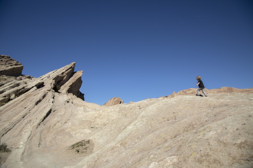
Vasquez Rocks
Where would you hide if you were chased by the law? Tiburcio Vásquez, a bona fide baddie who roamed the state in the mid-1800s, once eluded the law by hiding out in this wonderland of 25-million-year-old sedimentary slabs and rocks in modern-day Agua Dulce. He was charming, well dressed, educated and one of the bandits who inspired the fictional Zorro. Hidden gems to look for: rock art created by the Tataviam people who once called the area home. First-timers may find the rocks eerily familiar, with good reason: They’ve been used as the backdrop for countless Hollywood movies and TV shows.
![]()
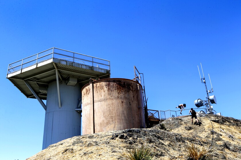
Mt. San Vicente
Come face to face with Cold War-era fear at a Nike missile site in the Santa Monica Mountains. It’s one of 16 places in Southern California that housed anti-aircraft missile launch sites. The site has been preserved and turned into San Vicente Mountain Park, which means you can see the missile structures up close. Signs help explain the era and the hardware. It’s a drive-up park, but better to go on foot and enjoy time on the trail in the Santa Monica Mountains. You’ll get good views from atop the 1,960-foot peak.
Park and start at Westridge and West Mandeville fire roads. Directions to trailhead.
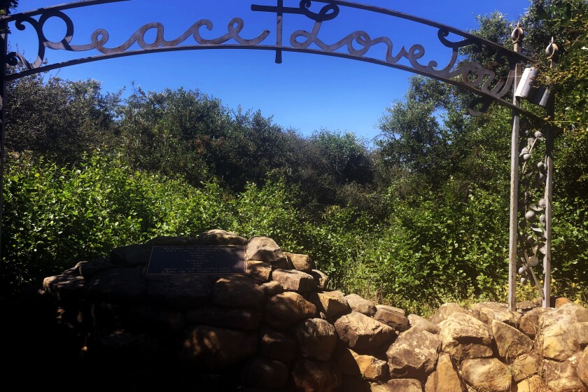
Danielson Monument
Peace out, man. The burial site of rancher Richard E. Danielson Jr. in Pt. Mugu State Park is framed by a large metal arch proclaiming “Peace, Love, Joy.” What better words to inspire? The memorial stands in a quiet place near the site of his old cabin. It’s about a mile or so beyond a seasonal waterfall below Boney Ridge. Danielson, who died in 1988, donated more than 5,500 acres to what eventually became the state park.
Start at the trail from Rancho Sierra Vista/Satwiwa in Point Mugu State Park, Newbury Park. Directions to trailhead.
![]()
Hellhole Canyon
What’s in a name? A likely question asked by all who visit Anza-Borrego Desert State Park’s Hellhole Canyon. Despite the name, it’s home to a heavenly oasis (and a helluva hike). Far less trafficked than nearby Borrego Palm Canyon, Hellhole offers a great workout among barrel cactuses and ocotillo before reaching the welcoming palms and sycamores of not one but two shaded desert oases. Climb the boulders, get out the binoculars and scan the cliffs for the park’s elusive mascot, the peninsular bighorn sheep. Continue up the creek by way of rock scrambling to reach Maidenhair Falls, a pleasant plus to your Anza adventure.
Park in the dirt lot (free) at Montezuma Valley Road, one mile south of Palm Canyon Drive. Directions to trailhead.
![]()
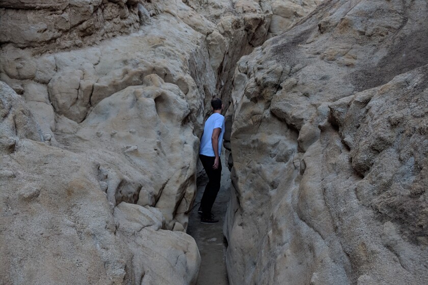
The Slot
No list of desert classics is complete without a trip through a slot canyon. Simply named the Slot, the narrow silt-stone canyon in Anza-Borrego is the place to squeeze, duck and maneuver through the geological ravine, which houses creosote bush and cholla cactus. Negotiating around the 40-foot rock walls is half the fun (or claustrophobic for some) and is especially awesome when the trench-traversing trail winds under a natural bridge formed by a sedimentary slab. The tapered slot itself is less than a mile, but you can steeply ascend to get views of the epic chasm, nearby West Butte Mountain and, farther out, the Laguna Mountains framing the desert backdrop. One caveat: Don’t go in heavy rains. $10 to park in dirt lot.
Start at the trail two miles north of California 78 near Buttes Pass Road. Directions to trailhead.
![]()
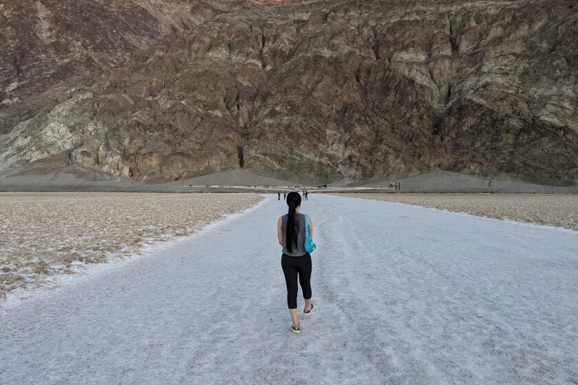
Badwater Basin Salt Flats
Want to go down in history? Everybody can at Badwater Basin Salt Flats in Death Valley National Park. At 282 feet below sea level, the mostly sodium chloride-covered flats cover nearly 200 square miles. The high-salinity habitat, home to an endemic snail and pickleweed, formed when water evaporated from an ancient lake. Walk over the crust toward prominent Telescope Peak (11,049 feet), which is particularly gorgeous at sunset. Check out the sea level marker on the cliffs to the east for another reminder that you are at the lowest point in North America. It’s all uphill from here. One last thing: Check out Dante’s View, a breathtaking lookout that offers a different perspective of the basin.
Park in paved lot and start on trail 17 miles south of Furnace Creek off Badwater Road. Directions to trailhead.
![]()
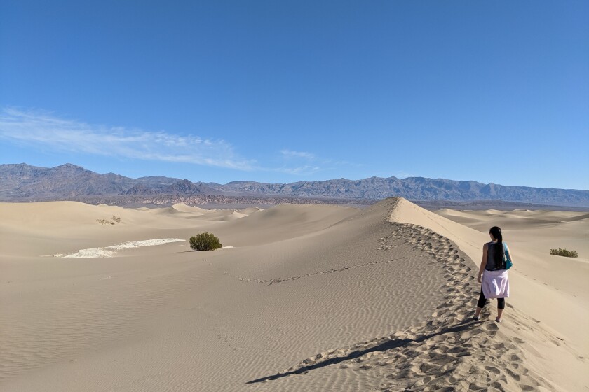
Mesquite Flats
Sometimes you gotta go your own way. Explore Death Valley’s Mesquite Flats with a dune-it-yourself journey through some of the most accessible and beautiful sand dunes in California. It’s easy to get otherworldly vibes, which is probably what inspired director George Lucas to use the setting for Tatooine in the “Star Wars” movies. The dunes are most comfortably explored from the ridges, the tallest of which rises more than 100 feet and offers a strenuous ascent up the sand (and a dramatic sand-boarding descent for thrill seekers). The desert vistas here are gorgeous at sunrise and sunset and provide a magical star-gazing opp.
Start two miles east of Stovepipe Wells on California 190. Directions to trailhead.
![]()
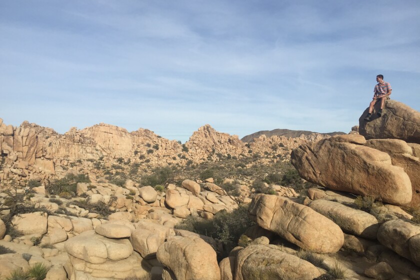
Hidden Valley/Barker Dam
If you have time to do only one hike during your trip to sprawling high-desert Joshua Tree National Park, do two. The Hidden Valley and Barker Dam trails are across the main road (Park Boulevard) from each other and provide the perfect highlight reel of the park’s geological, botanical and historical gems. Start at Hidden Valley, a loop enclosed by massive rock formations that were blasted by desert legend William Keys to gain easy access for cattle. Climb the rocks for incredible views of the circle of boulders and the area’s diverse plant life, including juniper, pinyon, yucca and, of course, Joshua trees. Continue your greatest hits tour at Barker Dam Nature Trail, where you can look for desert kit fox at sunset. The serene path also offers ancient petroglyph rock art and one of the most picturesque fields of Joshua tree in the park.
Park in a paved lot. Directions to trailhead.
![]()
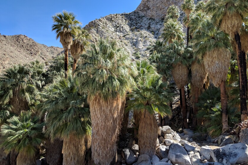
49 Palms Oasis
Are you tree lover, log lover, grove groupie? The copse of fan varieties at the 49 Palm Oasis in the northeast corner of Joshua Tree National Park is the place to go. On this roller coaster out and back, a steep, shadeless climb nets you rugged desert views to the north and vistas of the oasis. Coyotes, bighorn sheep and resident birds, such as Gambel’s quail and orange-and-black hooded orioles, rely on the space for water and a cooldown under the thicket of fan palms. You might even spot the rare desert tortoise on the trail; watch out on your drive in so you don’t hit one on the paved road. Enjoy bouldering or a peaceful picnic as you try and count all 49 floral specimens.
Free parking in paved lot; start 1¾ miles south of California 62 off Fortynine Palms Canyon Road. Directions to trailhead.
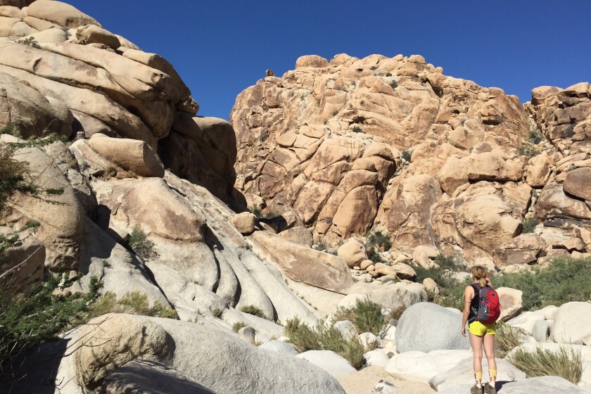
Rattlesnake Canyon
The park (affectionately dubbed JTree) is known for its endless climbing routes, but you don’t have to be Alex Honnold to get in on the fun. Enter Rattlesnake Canyon, a do-it-yourself rock scrambling adventure that lacks maintained paths or directional signs (and most likely, fellow hikers). The “trail” down a sandy wash among cottonwood trees and a monzonite-walled ravine soon dead ends. Keep going to explore the granite playground ascending into the canyon. As you scramble on the towering rocks, look for water pools and slot canyons and listen for croaks (California tree frogs), chirps (verdins) and, of course, rattles (the hike’s namesake serpents). The desert vistas are phenomenal, best enjoyed where the path plateaus.
Start at the Rattlesnake Canyon Picnic Area in Joshua Tree National Park, a little more than a mile east of Indian Cove Campground. Directions to trailhead.
![]()
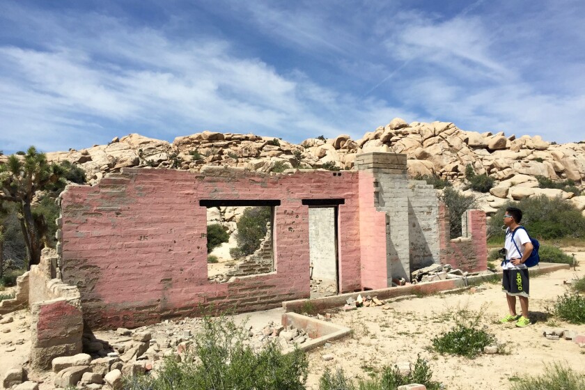
Wall Street Mill
You won’t find investment firms or hedge funds at Wall Street Mill in Joshua Tree, but you will find preserved ruins and mining history on an unoccupied trail through a peaceful landscape. The dirt path is lined with Joshua trees and, in spring, dense patches of desert dandelions, brittlebush and purple mat flowers. You can see a lot of historical junk — rusted cars, a windmill and the pink-walled remains of a ranch — on your way to the mill. This also is where desert pioneer William Keys shot and killed a neighbor in one of the last gunfights of the Old West. At the well-preserved stamp mill, scramble up a boulder to get a better perspective of the not-so-ancient gold-extracting site nestled among piñon pines and granite outcroppings. Talk about rich history!
Park at paved lot, start at Queen Valley Road just past Barker Dam. Directions to trailhead.
![]()
Willow Hole/Wonderland of Rocks
A journey into Joshua Tree always feels like a trip down the rabbit hole, but take a hike to Willow Hole on the Boy Scout Trail to discover a wonderland that channels your inner Alice. The hike begins gently in a dense field among vibrant succulents before entering the geological fantasyland. Trudge through the sandy wash and around the mad maze of monzogranite boulders that form the aptly named Wonderland of Rocks. Look for chuckwalla lizards on the exposed slabs and climb up to get a view of the surrounding region and Mt. San Gorgonio to the west. At the turn-around point, you reach a hidden watering hole amid dense green trees. Yep, these are willow trees.
Start on the Boy Scout Trail near Quail Springs Picnic Area. Directions to trailhead.

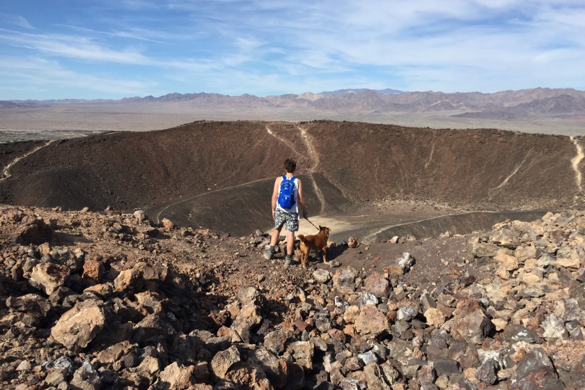
Amboy Crater
Panoramic desert vistas, wildflower fields and an ancient cinder cone volcano: What’s not to love about Amboy Crater in Mojave Trails National Monument? The extinct volcano, rising nearly 300 feet above the basalt lava plains surrounding it, last erupted 10,000 years ago. Today the hike traverses a lava field where jagged igneous rock contrasts with seasonal blooms such as desert sand verbena, sunflowers and fivespot. After a steep ascent to the rim by way of the western slope, you’re rewarded with expansive views of the Mojave preserve to the north as well as the Bullion and Bristol mountain ranges to the west and east, respectively. Don’t leave without exploring the 1,500-foot-diameter caldera of the national natural landmark.
Start at the parking lot (free) at Crater Road and Route 66 in Mojave Trails National Monument. Directions to trailhead.
![]()