
ASEAN WEATHER: Typhoon ‘Jolina (Philippines)- Conson (Viet Nam) set to take complex path
.
Typhoon Conson set to take complex path
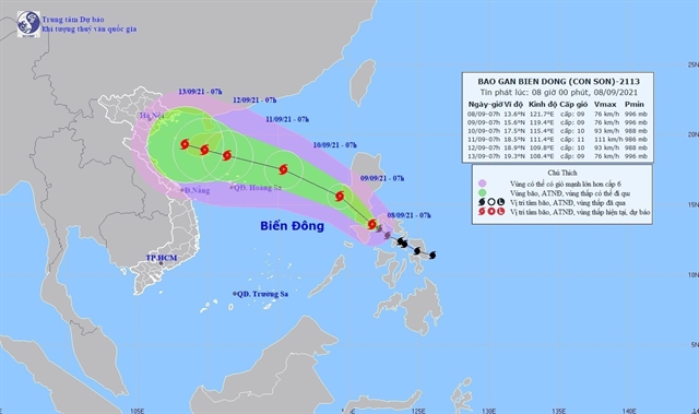
HÀ NỘI — Typhoon Conson will enter the East Sea (internationally known South China Sea) on Wednesday night and is forecast to take a complicated path.
According to the National Centre of Hydro-Meteorological Forecasting, at 2pm on Wednesday, the centre of the typhoon was in the south of Luzon Island in the Philippines with sustained average winds of 75 to 90km per hour near the typhoon eye, and up to 117km per hour gusts approaching level 11 on the Beaufort scale.
The typhoon is predicted to move northwest and head to the East Sea.
At 1pm on Thursday, it will be about 660km east-southeast of Hoàng Sa (Paracel) Islands with sustained winds of 75 to 90km per hour near the typhoon eye, and gusts approaching level 11.
It is forecast to move at a speed of 10-20km per hour and strengthen its power until it is about 220km northwest of the Hoàng Sa Islands at 1pm on Saturday. Then it will sustain wind power of 100 to 120km per hour, with gusts reaching level 13.
Experts have warned that fishermen and boatmen need to closely follow the typhoon development, as well as observe the sky and water surface to identify abnormalities of the weather.
Fishermen need to steer boats away from typhoon-affected areas.
Hoàng Phúc Lâm, deputy director of the National Centre of Hydro-Meteorological Forecasting, said there was another active typhoon on the East Sea named Chanthu.
It has sustained level 13-14, and was located about 1,100km east of Typhoon Conson on Wednesday.
It is predicted that after hitting the Philippines, the power and direction of Typhoon Conson will significantly change.
There is a high possibility that after weakening in the Philippines, when approaching the East Sea, Typhoon Conson will gain its strength. There is another possibility that Typhoon Conson will weaken and move to China or move south.
Typhoon Conson has interacted with islands and mainland areas of the Philippines and Typhoon Chanthu, making Conson unpredictable, Lâm said.
It is likely that Typhoon Conson will head to the East Sea and become the fifth typhoon to make landfall in Việt Nam this year. The mainland area has not been affected but the northern and central region will experience prolonged rain until Sunday.
The National Centre of Hydro-Meteorological Forecasting has asked local authorities of affected areas, especially 15 localities from Quảng Ninh to Bình Định to prepare response scenarios, especially in the context of the pandemic.
Depending on the situation, chairpersons of local People’s Committees are responsible for issuing offshore fishing bans.
Authorities in mountainous areas need to prepare plans to evacuate residents in areas prone to landslides and flash floods.
Some localities have prepared mass evacuation plans in areas with strong typhoons and heavy rains if the disaster level reaches level 3 out of 5.
If the disaster level reaches level 3, nearly 74,000 people in coastal areas, more than 114,000 people living along rivers and near dykes, and more than 70,000 residents in areas prone to flash floods and landslides will be relocated.
The National Steering Committee for Natural Disaster Prevention and Control held an online meeting with 15 provinces from Quảng Ninh to Bình Định on Wednesday to discuss preventive measures.
Deputy head of the committee Trần Quang Hoài asked authorities of the localities to seriously implement the Prime Minister’s direction to be ready to cope with natural disasters amid the context of the COVID-19 pandemic.
They were requested to prepare measures to evacuate people in case of strong storms, heavy rain, flash floods and landslides while ensuring COVID-19 prevention and control following guidelines from the Ministry of Health.
According to the National Centre of Hydro-Meteorological Forecasting, there will be six to eight more typhoons or tropical depressions in the East Sea this year, including two to four typhoons/tropical depressions directly affecting the mainland. — VNS
.

‘Jolina’ seen to exit PAR on Thursday; ‘Kiko’ continues to intensify
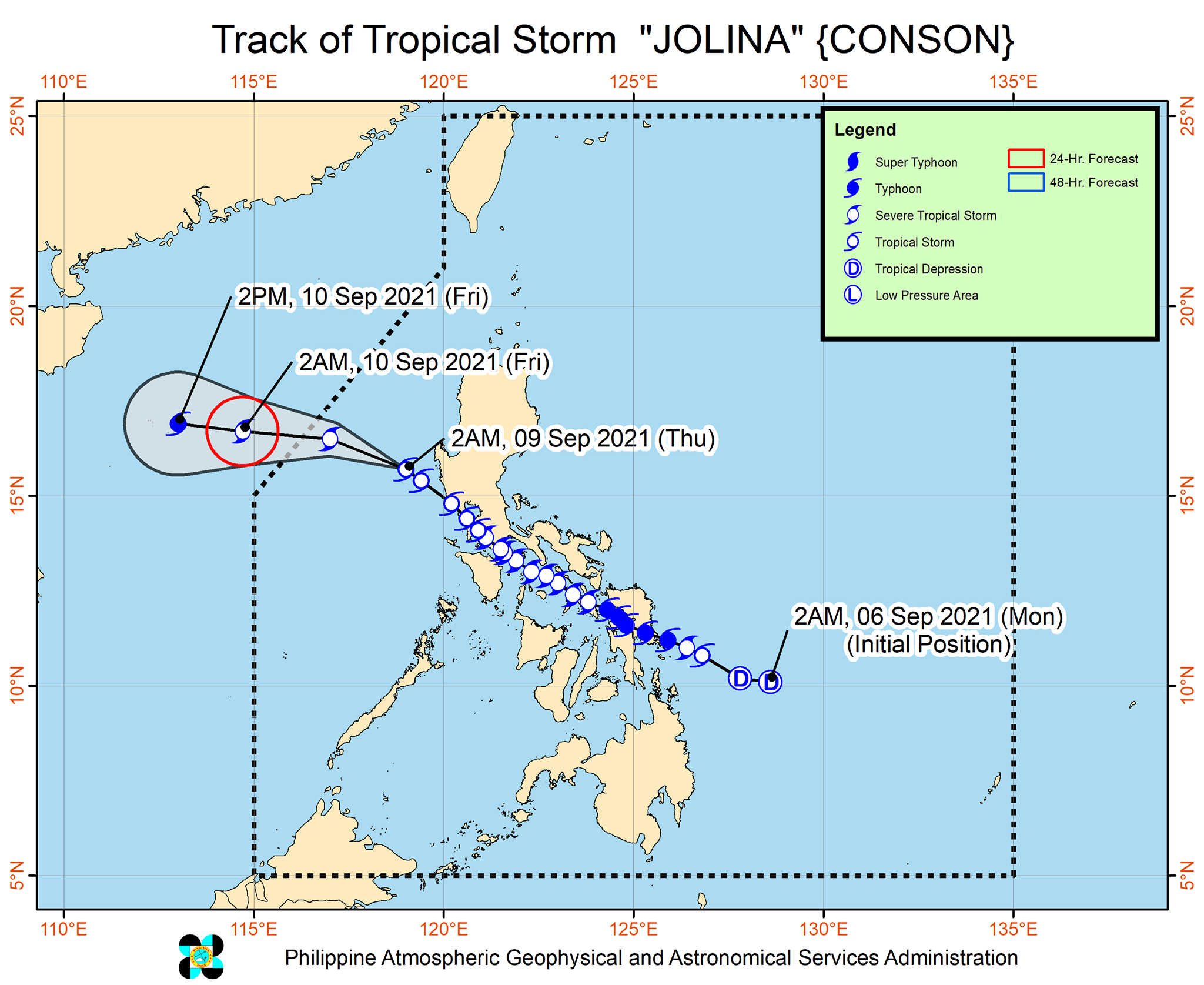
MANILA, Philippines — Severe Tropical Storm Jolina is forecast to exit the Philippine Area of Responsibility on Thursday afternoon or evening while Typhoon Kiko continues to intensify, state weather bureau PAGASA said.
Jolina maintained its strength as it moves away from Luzon landmass. At 4 a.m., it was located 145 km west northwest of Iba, Zambales or 175 km west of Dagupan City, Pangasinan with winds of 85 kph and gusts of up to 115 kph. It is moving northwestward at 25 kph.
Tropical Cyclone Wind Signal no. 1 is hoisted over:
- the western portion of Pangasinan (Anda, Bolinao, Infanta, Aguilar, Sual, Labrador, Dasol, Bugallon, Burgos, Mabini, Agno, City of Alaminos, Bani, Lingayen, Mangatarem)
- the northern portion of Zambales (San Antonio, Botolan, San Narciso, San Felipe, Cabangan, Palauig, Iba, Masinloc, Candelaria, Santa Cruz)
What to expect
- Light to moderate with at times heavy rains over Zambales, Bataan and Pangasinan
- Strong winds (strong breeze to near gale conditions) with occasional gusts in areas under Signal No. 1
- Moderate to rough seas (1.5 to 4.0 m) over the western seaboard of Luzon
Forecast positions
- Friday morning: 605 km west of Dagupan City, Pangasinan (outside the PAR)
- Friday afternoon: 790 km west of Dagupan City, Pangasinan (outside the PAR)
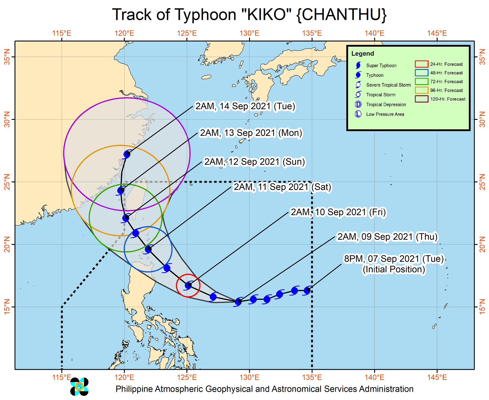
‘Kiko’ resumes intensification
Typhoon Kiko, meanwhile, is forecast to pass very close to northeastern Cagayan and cross the vicinity of Babuyan Islands between Friday afternoon and early Saturday morning.
“Given the recent southward shift in the track forecasts of “KIKO” from the previous bulletins, the possibility of landfall over mainland Cagayan is not yet ruled out,” PAGASA said.
At 4 a.m., Kiko was located 785 km east of Baler, Aurora with winds of 185 kph and gusts of up to 230 kph. It is moving westward at 20 kph.
Tropical Cyclone Wind Signal no. 1 is raised over:
- the eastern portion of Cagayan (Buguey, Lal-Lo, Santa Teresita, Gonzaga, Santa Ana, Gattaran, Baggao, Peñablanca)
- the northeastern portion of Isabela (Maconacon, Divilacan, San Pablo, Cabagan, Palanan)

What to expect
- Heavy to intense with at times torrential rains over Batanes, Cagayan including Babuyan Islands and northern Isabela
- Moderate to heavy with at times intense rains over Batanes and the rest of Isabela
- Winds reaching strong breeze to near gale in strength (i.e, strong winds) with occasional gusts will be experienced within 36 hours within the areas under Signal No. 1
- High waves near the coast and storm surge may affect several coastal municipalities in Northern Luzon
- Moderate to very rough seas (1.5 to 2.8 m) initially and becoming rough to very rough seas (2.5 to 5.0 m) will prevail over the eastern seaboard of Northern Luzon
- Moderate to rough seas (1.2 to 2.8 m) will be experienced over the northern seaboard of Northern Luzon and the eastern seaboards of Central and Southern Luzon
Forecast positions
- Friday morning: 320 km east of Casiguran, Aurora
- Saturday morning: Over the coastal waters of Babuyan Island, Calayan, Cagayan
- Sunday morning: 230 km northwest of Itbayat, Batanes
- Monday morning: 450 km north northwest of Itbayat, Batanes (outside the PAR)
- Tuesday morning: In the vicinity of Ningde, Fujian Province, China or 730 km north northwest of Itbayat, Batanes (outside the PAR)