SCI-FI- SPACE EXPLORATION: KOUROU, France (Guiana) – World’s most powerful telescope blasts off into space
.

KOUROU (AFP) – The world’s most powerful space telescope on Saturday blasted off into orbit, headed to an outpost 1.5 million kilometres from Earth, after several delays caused by technical hitches. .
.
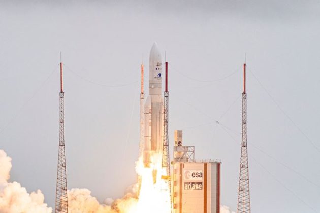
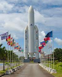
Ariane 5 rocket lifts off for it’s 100th mission to space from Kourou, French Guiana, on September 25, 2018. (AFP/Jody Amiet)
Share News Desk (AFP) Kourou, France ● Sat, December 25, 2021
.
The world’s most powerful space telescope is set to blast off on Saturday to its outpost 1.5 million kilometres (930,000 miles) from Earth, after several delays caused by technical hitches.
.
The James Webb Space Telescope, some three decades and billions of dollars in the making, will leave Earth enclosed in its Ariane 5 rocket from Kourou Space Centre in French Guiana.
.
The launch, scheduled in a brief window after 9:20 am (1220 GMT), will send the telescope on a month-long journey to its remote orbit.
.
It is expected to beam back new clues that will help scientists understand more about the origins of the Universe and Earth-like planets beyond our solar system.
.
Named after a former NASA director, Webb follows in the footsteps of the legendary Hubble — but intends to show humans what the Universe looked like even closer to its birth nearly 14 billion years ago.
.
Speaking on social media, Webb project co-founder John Mather described the telescope’s unprecedented sensitivity. x “#JWST can see the heat signature of a bumblebee at the distance of the Moon,” he said.
.
All that power is needed to detect the weak glow emitted billions of years ago by the very first galaxies to exist and the first stars being formed.
.
‘Exceptional measures’ The telescope is unequalled in size and complexity. Its mirror measures 6.5 metres (21 feet) in diameter — three times the size of the Hubble’s mirror — and is made of 18 hexagonal sections.
.
It is so large that it had to be folded to fit into the rocket. That manoeuvre was laser-guided with NASA imposing strict isolation measures to limit any contact with the telescope’s mirrors from particles or even human breath.
.
Once the rockets have carried Webb 120 kilometres, the protective nose of the craft, called a “fairing”, is shed to lighten the load. To protect the delicate instrument from changes in pressure at that stage, rocket-builder Arianespace installed a custom decompression system.
.
“Exceptional measures for an exceptional client,” said a European Space Agency official in Kourou on Thursday.
.
Crew on the ground will know whether the first stage of the flight was successful about 27 minutes after launch. Once it reaches its station, the challenge will be to fully deploy the mirror and a tennis-court-sized sun shield.
.
That intimidatingly complex process will take two weeks and must be flawless if Webb is to function correctly. Its orbit will be much farther than Hubble, which has been 600 kilometres above the Earth since 1990.
.
The location of Webb’s orbit is called the Lagrange 2 point and was chosen in part because it will keep the Earth, the Sun and the Moon all on the same side of its sun shield.
.
Webb is expected to officially enter service in June.
This article was published in thejakartapost.com with the title ” James Webb telescope set for launch on million-mile voyage “.
Click to read: https://www.thejakartapost.com/culture/2021/12/25/james-webb-telescope-set-for-launch-on-million-mile-voyage-.html.
SPACE RESERVE FOR ADVERTISEMENT

/
TRIVIA:
SPACE RESERVE FOR ADVERTISEMENT
/
Kourou
 Description
SPACE RESERVE FOR ADVERTISEMENT
/
Kourou
Kourou is a commune in French Guiana, an overseas region and department of France in South America. It is an administrative district in French Guiana and the main town there.
Within the Kourou district lies the Guiana Space Centre, the main spaceport of France and the European Space Agency.
SPACE RESERVE FOR ADVERTISEMENT
/
Geography

Beach at Kourou, 2005
Some 60 km (37 mi) northwest of the French Guianese capital Cayenne the Kourou River empties into the Atlantic Ocean. At the mouth of this river sits the town of Kourou, which is ringed by four hills: Carapa, Pariacabo, Café and Lombard, with the Singes and Condamine mountains not far behind. There are three lakes within the town’s city limits: Lake Bois Diable (where one can take lessons in jetski and other aquatic sports), Lake Marie-Claire (the smallest and calmest), and Lake Bois Chaudat (the biggest of the three; also open to sport lovers, especially canoers and kayakers). Long white sand beaches and some rocky outcrops line the town’s ocean coast, the riverbank and all points inland consisting mostly of mangrove and dense tropical rainforest.
The town had a population of 25,685 inhabitants at the 2017 census. Its inhabitants can be classified into three ethnic groups of roughly equal size:
- Indigenous peoples (mostly Kalina – also called Galibi), Creoles, Maroons (Boni and Saramaka),
- Whites (mostly French, from Metropolitan France), and
- Foreigners (Brazilians, Surinamese, Hmong, Haitians, Guyanese, etc.)
The Saramaka mostly settled in the quartier Saramaka, along the river. In 2006, a fire rendered 55 people homeless.[3]
Guiana in general has a high level of crime compared to the rest of France’s départements; Kourou has an average of two armed robberies a day. A march protesting the high level of insecurity felt by most of the population was held in Kourou on 27 October 2006.[4] Shopkeepers of Chinese descent in particular are often targeted by armed robbers, their cash registers emptied and some products stolen.
Kourou is the port of departure for those going to the Iles du Salut, of which the most famous is Devil’s Island. It is also common for many to go up the river in canoes on weekends to camp in the forest.
The Guiana Space Centre, where the European Space Agency starts missions, is located a little behind and outside the town. Part of the town and the islands are closed during rocket launches.
In 2010, the Kourou solar power plant was built near Kourou on Aubanèle Savannah. It is the largest solar power plant in Overseas France.[5]
SPACE RESERVE FOR ADVERTISEMENT
/
Climate
Like most of French Guiana, Kourou has an equatorial climate (Köppen Af) bordering on a tropical monsoon climate (Köppen Am) with a short dry season centered between the months of August and October when the Intertropical Convergence Zone is furthest north. During the remainder of the year rainfall is always heavy. Between November and July a total of 2,396.4 millimetres or 94.35 inches can be expected in nine months, with rain on most days and very cloudy skies.
| hideClimate data for Kourou, French Guiana (1981–2010 averages) | |||||||||||||
|---|---|---|---|---|---|---|---|---|---|---|---|---|---|
| Month | Jan | Feb | Mar | Apr | May | Jun | Jul | Aug | Sep | Oct | Nov | Dec | Year |
| Record high °C (°F) | 31.3 (88.3) |
31.7 (89.1) |
31.6 (88.9) |
31.8 (89.2) |
32.4 (90.3) |
31.9 (89.4) |
33.0 (91.4) |
33.7 (92.7) |
34.0 (93.2) |
34.5 (94.1) |
33.5 (92.3) |
32.7 (90.9) |
34.5 (94.1) |
| Average high °C (°F) | 29.0 (84.2) |
29.1 (84.4) |
29.4 (84.9) |
29.6 (85.3) |
29.6 (85.3) |
29.7 (85.5) |
30.4 (86.7) |
31.0 (87.8) |
31.7 (89.1) |
31.9 (89.4) |
31.2 (88.2) |
29.8 (85.6) |
30.2 (86.4) |
| Average low °C (°F) | 23.8 (74.8) |
24.0 (75.2) |
24.2 (75.6) |
24.3 (75.7) |
23.9 (75.0) |
23.2 (73.8) |
22.7 (72.9) |
22.8 (73.0) |
22.6 (72.7) |
22.8 (73.0) |
23.1 (73.6) |
23.7 (74.7) |
23.4 (74.1) |
| Record low °C (°F) | 19.2 (66.6) |
20.0 (68.0) |
19.5 (67.1) |
19.0 (66.2) |
20.0 (68.0) |
20.0 (68.0) |
20.0 (68.0) |
19.1 (66.4) |
19.1 (66.4) |
19.0 (66.2) |
18.1 (64.6) |
18.8 (65.8) |
18.1 (64.6) |
| Average rainfall mm (inches) | 358.4 (14.11) |
220.3 (8.67) |
265.9 (10.47) |
391.0 (15.39) |
503.2 (19.81) |
377.1 (14.85) |
148.6 (5.85) |
87.7 (3.45) |
32.8 (1.29) |
49.1 (1.93) |
123.8 (4.87) |
280.5 (11.04) |
2,838.4 (111.73) |
| Average rainy days | 20.67 | 17.07 | 17.03 | 20.27 | 24.87 | 23.83 | 15.93 | 8.53 | 4.43 | 6.40 | 11.80 | 20.13 | 190.96 |
| Mean monthly sunshine hours | 119.9 | 116.1 | 149.2 | 138.6 | 142.9 | 172.3 | 219.6 | 248.5 | 259.9 | 250.6 | 204.8 | 141.4 | 2,163.7 |
| Source: Meteo France[6][7] | |||||||||||||
SPACE RESERVE FOR ADVERTISEMENT
/
History
Before the Europeans

Kourou’s Bois Chaudat lake during the rainy season.
Not much is known of the pre-colonial era. The area was mostly populated by Kalina, or Galibi before the arrival of the French in the late 17th century.
Not far from the town at Les Roches Gravées (The Carved Rocks), indigenous art can be seen on the rock walls.
SPACE RESERVE FOR ADVERTISEMENT
/
Early colonization
Vicente Yáñez Pinzón sailed along most of the north coast of South America and passed by the current location of Kourou in 1500.
The Jesuits Lombard and Creuilly baptised a few Galibis at the church of Saint Nicholas in Cayenne in December 1710 and returned with them soon after to farm the land at Guatémala, across the river from Kourou. The Society of Jesus was disbanded (in Guiana) in 1762, however, and Kourou was nothing more than a small village until the arrival of the Expedition.
In 1744, La Condamine, in charge of the expedition sent to Peru in 1735 to determine the length of a degree of the meridian arc in the neighbourhood of the equator, passed by and gave his name to one of the mountains behind Kourou.
SPACE RESERVE FOR ADVERTISEMENT
/
Expedition

The Bourg, 2006
The mission at Kourou being abandoned by the Jesuits, the engineers Mentelle and Tugny designed the layout of the future town. This resulted in the neighbourhood called the Bourg, around the Church of Saint Catherine and next to the port on the river.
That same year, 1763, as agreed in the Treaty of Paris, Great Britain took control of New France. Having lost their largest and richest colony, the French decided to send a large expedition to Guiana, commanded by Choiseul. Around 10,000 to 12,000 people, mostly Frenchmen, tempted by stories of an El Dorado on the other side of the ocean, settled in Kourou.
The small town, surrounded by marshes and rainforest, was unprepared for such a massive influx of people, and around 6,000 of the pioneers died within the year due to fevers and other illnesses. Those remaining fled to the îles du Salut, free of mosquitoes due to constant winds, to recover before being repatriated to Metropolitan France. Hence the name, “Salvation Islands.” Previously they had been known as the îles du Diable (“Devil’s Islands”), and one of the islands retains the name to this day.
The failure of the Expedition only served to discourage settling in Guiana. The colony earned the nickname Enfer Vert (“Green Hell”), which it is still trying to shake. No other project of mass colonisation was undertaken, and the population of Whites was always drastically lower than that of the slaves. The population of the colony, of all races, did not rise above 20,000 until the gold rush (starting in 1855), the second abolition of slavery in 1848 and the founding of the prisons.
Prisons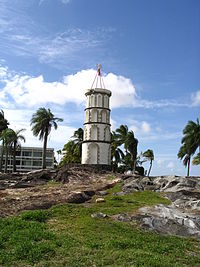

The Dreyfus Tower on the Pointe des Roches, 2005
Kourou was formerly the home of the “Kourou Prison” which was one of the main prisons in French Guiana, and which was also a part of the notorious Devil’s Island Prison System. The Kourou Prison was dedicated mostly to agriculture.
In 1852 the three main islands off of Kourou’s coast, the Salut island group (which included Devil’s Island) also became prisons. These island prisons held mostly political prisoners, as well as some of France’s toughest criminals. The first prisoners arrived in 1862.
In 1938, a law was passed prohibiting the transport of any new prisoners from France to French Guyana. In 1946 eight years later, the Kourou Prison was finally shut down, while some prisoners were kept in other Guyanese prisons until as late as 1953.
After the closing of the prison, most of the prison buildings were demolished to make room for the Hôtel des Roches, but some vestiges of that period remain. One notable remnant of the prison is the Dreyfus Tower, which stands where the river meets the ocean. This tower was used in pre-radio days to communicate with the islands via Semaphore. Other prison ruins that remain are the prison bakery — now on private property, but still visible from a cul-de-sac — and an old prison fountain near the moucaya palm trees.
SPACE RESERVE FOR ADVERTISEMENT
/
CSG and the French Foreign Legion Arrive
In 1965, the Guiana Space Centre was founded a little behind the town by the CNES. With the launch facility being used by the European Space Agency since 1975, the urbanisation of Kourou began in earnest.
The 3rd Foreign Infantry Regiment of the French Foreign Legion, whose mission is to protect the CSG, has had a base in the Forget neighbourhood since 1973. They clashed with the Creoles in 1985 and 2006.[8]
SPACE RESERVE FOR ADVERTISEMENT
/
Demographics
Historical population
| Year | Pop. | ±% p.a. |
|---|---|---|
| 1961 | 659 | — |
| 1967 | 3,117 | +29.56% |
| 1974 | 4,720 | +6.11% |
| 1982 | 7,061 | +5.16% |
| 1990 | 13,873 | +8.81% |
| 1999 | 19,107 | +3.62% |
| 2008 | 25,934 | +3.45% |
| 2013 | 25,793 | −0.11% |
| 2018 | 24,959 | −0.66% |
| Source: SPLAF[9] and INSEE[10] | ||
SPACE RESERVE FOR ADVERTISEMENT
/
Migrations
The places of birth of the 26,221 residents in the commune of Kourou at the 2015 census were the following:[11]
- 48.7% were born in French Guiana
- 16.0% in Metropolitan France
- 2.0% in Martinique
- 0.9% in Guadeloupe
- 0.4% in other parts of Overseas France
- 32.2% in foreign countries (notably Suriname, followed by Haiti and Brazil); among these, 30.7% were immigrants and 1.4% were children of French citizens born abroad
These were the countries of birth of the immigrants living in the commune of Kourou at the 2009 census:[12]
- born in Suriname: 3,035
- born in Haiti: 1,857
- born in Brazil: 1,806
- born in other countries: 1,327
SPACE RESERVE FOR ADVERTISEMENT
/
Economy
Kourou’s economy is largely dominated by the CSG, from which the European Ariane rockets are launched, as well as the Russian Soyuz and the Italian Vega rockets.
Transportation
Kourou is served by Kourou Airport, located 2 kilometres (1.2 mi) at the west of the city.
Politics
Kourou is the main town on an “administrative district” of French Guyana. Such a district is equivalent to a county in the United States.
SPACE RESERVE FOR ADVERTISEMENT
/
Tourism
- The Centre Spatial Guyanais (CSG) gets many visitors all year round.
- The Musée de l’Espace is a museum devoted to space and space exploration.
- The Salvation Islands: Of the three islands, only two, Île Royale and Île Saint-Joseph, can be visited. The third is Devil’s Island.
- Les Roches gravées: Indigenous rock art, not far from the small industrial zone called Pariacabo.
- There are several marked public footpaths in the jungle, of which the most well-known and used is the one on the Montagne des Singes.
- Kourou River: Many people go up the river on canoes or small boats to camp along the shore in open dwellings, or simply in hammocks.
- The ocean may not be clear (it is brown due to the Amazonian silt), but both it and the beaches are clean.
SPACE RESERVE FOR ADVERTISEMENT
/
Popular culture
This Commune is also featured in the 2021 video game Battlefield 2042 as the setting of multiplayer map Orbital.[13]
See also
SPACE RESERVE FOR ADVERTISEMENT
/
References
- ^ “Répertoire national des élus: les maires”. data.gouv.fr, Plateforme ouverte des données publiques françaises (in French). 2 December 2020. Retrieved 7 December 2020.
- ^ “Populations légales 2018”. The National Institute of Statistics and Economic Studies. 28 December 2020.
- ^ “Un incendie cette nuit au village Saramaca”. Blada (in French). Archived from the original on 23 February 2011. Retrieved 14 December 2021.
- ^ (in French) http://www.blada.com/jodlas/1561-Kourou_:_une_ville_sans_oreilles.htm Article on Blada.com about the march (with photos).
- ^ “Kourou solar power plant”. Albioma. Retrieved 14 December 2021.
- ^ “Données climatiques de la station de Kourou” (in French). Meteo France. Retrieved January 5, 2016.
- ^ “Climat Guyane”. Meteo France. Retrieved January 5, 2016.
- ^ Le Monde, 10.08.06 (in French)
- ^ SPLAF. “Agglomérations et villes de la Guyane”. Retrieved 12 April 2021.
- ^ Populations légales 2018: Commune de Kourou (97304), INSEE
- ^ “Recensement de la population de 2015 – Individus localisés au canton-ou-ville en 2015”. INSEE. Retrieved 2019-02-03.
- ^ “Panorama de la population immigrée en Guyane” (PDF). INSEE. Retrieved 2019-02-03.
- ^ Arts, Electronic (2021-06-07). “Battlefield 2042 Maps – Electronic Arts”. Electronic Arts Inc. Retrieved 2021-06-12.