
OP ED | Understanding the nine-dash phantom line

First of 3 parts
IN recent days, this paper has been the venue for the dominant American propaganda line against China’s alleged expansionism in the South China Sea. Not coincidentally this line, a lie, was put into high gear after President Obama launched his so-called Pivot to Asia policy, a thinly disguised program to contain the rise of China as the Asian superpower.
That line goes like this: China on its own drew a nine-dash line around most of the South China Sea on its map of its territory, and then claims everything within it as its own, demanding that the world, especially the nations bordering that sea, to recognize its sovereignty over the features and waters inside the line. China bashers here and abroad have claimed that the line is “the main driver of the South China dispute.”
 Memento Maxima Digital Marketing
Recently, a columnist cut-and-pasted reviews (not even the publication itself) of a book he raved over as explaining definitely, what the nine-dash line is and that it has no basis in international law. The book’s cleverness — and that of American propagandists — is that it exploits people’s fondness for fairy tales, with heroes or villains. In that particular book, it claims that “a singular cartographic combatant” in 1936 created that nine-dash line that the author asserts “is at the heart of today’s struggle over the South China Sea.” The heights of imagination indeed; “A cartographic combatant!”
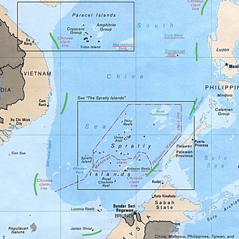
This is a bit preposterous. The Chinese don’t even provide the precise geographical coordinates for that nine-dash line. This is in contrast for instance to the geographic coordinates that determined Philippine territory in the1898 Treaty of Paris, or those defining in 1978 the Kalayaan Island Group (KIG). What’s the use of a line on a map if it doesn’t have geographical coordinates?
And of course, there’s the simple question: If it defines Chinese sovereign territory, why is it in dashes, and not a solid line, as a nation’s borders are represented in most maps?
We better get the real score on what this nine-dash line means, since its widespread misunderstanding — a testament to America’s powerful propaganda machine — explains not a few officials’ odium toward China, so much so they say, that they’d be willing to go to war against it to defend Philippine sovereignty.
Rather than cutting and pasting an explanation of the nine-dash line, and quoting experts or Pulitzer Prize winners, I am posting here in three parts the complicated story over this nine-dash line, actually excerpts from my 2022 book Debacle: The Aquino Regime’s Scarborough Fiasco and the South China Sea Arbitration Deception which I wrote after two years of research. Due to a column’s format, I have deleted the notes (sources of information) that are in the book, which if you read the book itself, refers mostly to studies by European (i.e., unbiased) scholars.

Excerpts from the book
The claim that the nine-dash line is the “main driver of the South China Sea dispute” is nonsense. Rather, it is the “main driver” of the propaganda machine demonizing China as an expansionist in the South China Sea. Its propaganda power draws from the confusion — deliberately spread by officials of the past Aquino 3rd administration and the US — over maritime entitlements as defined by the United Nations Convention on the Law of the Sea (Unclos) and China’s claims of sovereignty over four island groups in the South China Sea.
“Maritime entitlement” refers mainly to the exclusive economic zone (EEZ) that according to Unclos consists of the waters 200-nautical miles seaward from a coastal state’s baselines which roughly define its sovereign territory. The territorial sea consists of the waters at most 12 nautical miles seaward from its baselines which define its sovereign territory.
The arbitral panel in the suit that the Aquino 3rd government brought against China in 2014 to rule on their disputes indeed upheld the Philippine claim: “The Chinese claims to areas encompassed by the U-shaped, dotted line are contrary to the Convention and without lawful effect to the extent that they exceed the geographic and substantive limits of China’s maritime entitlements under the Convention.”
However — and this is a colossal “however” — China’s sovereign claims in the South China Sea are not based on the nine-dash line. The Chinese justifications for its claims mention the “nine-dash line” only in passing, and that it “indicates” the location of the four island groups, one of which is the Spratlys, or Kalayaan Island Group to us, it claims sovereignty over, regardless of the nine-dash line. While China in the future conceivably may claim the nine-dash line as indeed marking its sovereign boundaries, it has not done so far. The arbitral panel’s ruling that the nine-dash line has no basis in Unclos is totally irrelevant to its sovereign claims over the island groups in the SCS.
Sovereign
China’s sovereign claims are based, putting aside in this discussion its allegations of historic rights since 2,000 years ago, on its state’s actions of claiming sovereignty — and enforcing it even in a limited way — in the early decades of the last century. It was the first state to do so for those areas and until the 1970s, unchallenged by the Philippines, Vietnam, and even the US.
In China’s official “Position Paper on the Matter of Jurisdiction in the South China Sea Arbitration,” dated Dec. 7, 2014, there is no mention of the line at all in its summary of its arguments for its sovereignty over the SCS archipelagos:
“In 1935, the Commission of the Chinese Government for the Review of Maps of Land and Waters published the Map of Islands in the South China Sea. In 1948, the Chinese Government published the Map of the Location of the South China Sea Islands. Both maps placed under China’s sovereignty what are now known as the Nansha Islands (Spratlys) as well as the Dongsha Islands (Pratas), the Xisha Islands (Parcels) and the Zhongsha Islands (Macclesfield Bank).
“The Declaration of the Government of the People’s Republic of China on the Territorial Sea of 1958 declared that the territory of the People’s Republic of China includes, inter alia, the Nansha Islands. In 1983, the National Toponymy Commission of China published standard names for some of the South China Sea Islands, including those of the Nansha Islands. The Law of the People’s Republic of China on the Territorial Sea and the Contiguous Zone of 1992 again expressly provides that the Nansha Islands constitutes a part of the land territory of the People’s Republic of China.”
Declarations
In those declarations, nor in any other official document on China’s position on the South China Seas disputes, there is no mention at all of the nine-dash line.
However, with the arbitral panel’s ruling that the nine-dash line has no basis under Unclos, the Aquino 3rd government and the US have disseminated the fallacy that therefore China has no rights at all over the Reed Bank, the Spratlys, and Scarborough Shoal (or Bajo de Masinloc). That line has been repeated again and again, in the fashion of the Nazi principle of the “Big Lie,” recently by the US ambassador to the Philippines; “The international arbitral panel ruled China’s nine-dash line as without legal basis.”
The deviousness of the suit and the entire American propaganda lay in the fact that the tribunal, or any court, has no authority to rule on nations’ competing sovereign claims. So it remained silent on China’s sovereign claims, yet ruled that China through its nine-dash line has no rights to the disputed territories.
However, it was in the part of the suit involving Bajo de Masinloc that the tribunal laid bare the fact that its ruling on the nine-dash line was inconsequential: “The Tribunal records that this decision is entirely without prejudice to the question of sovereignty over Scarborough Shoal.”
Shoal
But the Shoal is within the nine-dash line, which the award declared as without legal basis. The arbitral panel therefore was implicitly saying that China’s claim over Scarborough Shoal — and by extension the Spratlys
— is not based on the nine-dash line or on its maritime entitlements but, as in fact has been China’s argument, on its sovereign claims on Scarborough Shoal (Huangyan Dao to the Chinese) that it claims is part of its territory, the Zhongsha Islands.
Another indication very relevant to us that the line doesn’t represent China’s boundaries: the Malampaya Well off Palawan which has produced and generated $12 billion in revenues for the Philippine government is within the nine-dash line but China has not claimed it. Just 250 kilometers away is the Reed Bank, which China claims is theirs as it is located within its Zhongsha island group (Macclesfield Bank), where its vessels shooed away a Philex vessel from undertaking oil exploration.
Similarly, the panel did not rule on whether China has sovereignty or not over the other features in the Spratlys, even if these are within the nine-dash line. Again, this implicitly recognized that China’s justification for its occupation is not based on that U-shaped demarcation, as discussed below.
The panel only declared that the nine-dash line had no validity in terms of Unclos’ provisions, which do not deal and cannot deal with claims of sovereignty over territory but only with maritime entitlements (mainly the exclusive economic zones) generated from territories.
But it did not apply this ruling to decide on whether or not China has valid sovereign or sovereign rights claims over Reed Bank, Scarborough Shoal, and seven reefs in the Spratlys that it has occupied.
Nothing
Nothing in all the Chinese government’s statements and declarations has it referred to the nine-dash line as the basis for its sovereignty over the Spratlys, Scarborough Shoal, Reed Bank and other areas in the South China Sea.
Even China’s 2009 note verbale to the United Nations (protesting the joint submission by Vietnam and Malaysia of the extent of their continental shelves), which had the line on the map it submitted, did not mention the nine-dash line, much less explain what it is. The Aquino 3rd government’s 2014 arbitration suit however claimed, but falsely, that it was after this submission that China started claiming all of the areas within it.
If the nine-dash line does not represent China’s territorial boundaries in the South China Sea then what is it? Why is it not in all official Chinese maps even?
More on that on Friday, March 17.
Facebook: Rigoberto Tiglao
Twitter: @bobitiglao
Archives: www.rigobertotiglao.com
Book orders: www.rigobertotiglao.com/shop
 Ads by: Memento Maxima Digital Marketing