

WEATHER: TYPHOON | ASEAN WATCH- Typhoon ‘Chedeng’ enhances habagat while moving away from Philippines
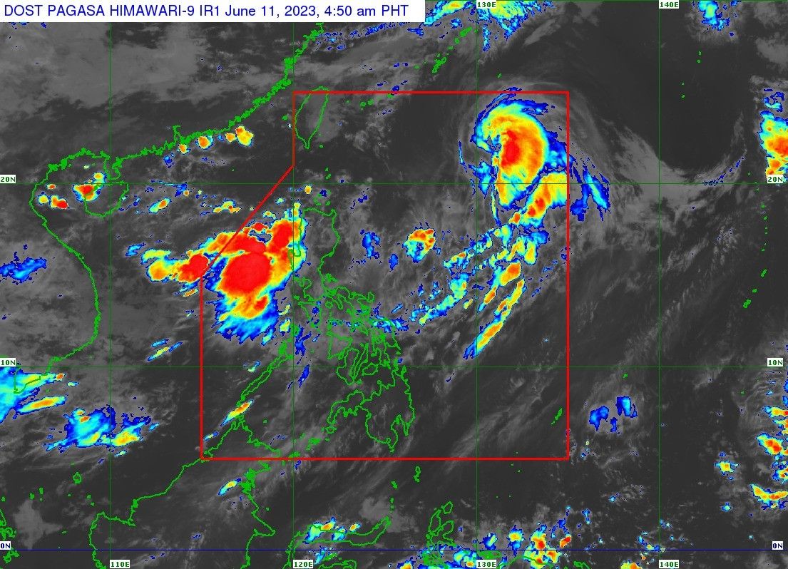
Chedeng’s center was last located the typhoon’s center 990 kilometers away from the east of extreme northern Luzon, moving north-northeastward at 20 km per hour with winds up to 130 kph near the center and gusts of 160 kph.
As of:

MANILA, Philippines — Despite moving away from the Philippines and being on track to leave the country’s monitoring area, Typhoon Chedeng (international name: Guchol) is expected to continue enhancing the southwest monsoon in the coming week.
According to an advisory issued at 5 a.m., the state weather bureau last located the typhoon’s center 990 kilometers away from the east of extreme northern Luzon, moving north-northeastward at 20 km per hour with winds up to 130 kph near the center and gusts of 160 kph.
PAGASA weather specialist Grace Castañeda said Chedeng may weaken into a severe tropical storm either Sunday or early Monday morning.
 Memento Maxima Digital Marketing
“This does not have a direct effect on any part of the country but it does continue to enhance the southwest monsoon, which is bringing rains over the western sections of Luzon and Visayas,” Castañeda said in a 5 a.m. briefing.
No tropical cyclone wind signal has been hoisted over any part of the country, although PAGASA said it may cause moderate to rough seas in extreme northern Luzon in the next 24 hours.
Chedeng may cause gusty or stormy conditions over Batanes, the Babuyan islands, Ilocos region, the Cordillera Administrative Region, Nueva Vizcaya, Central Luzon, Metro Manila, CALABARZON, MIMAROPA, the Bicol region, and Western Visayas.
Chedeng’s forecast position:
- Jun 11, Sunday at 2 p.m. – 1,170 km east northeast of extreme northern Luzon
- Jun 12, Monday at 2 a.m. – 1,455 km east northeast of extreme northern Luzon (outside PAR)
- Jun 12, Monday at 2 p.m. – 1,850 km east northeast of extreme northern Luzon (outside PAR)
While the typhoon may exit the country’s monitoring area by Sunday evening or early Monday, the state weather service expects gusty conditions to continue over the majority of the Luzon islands Tuesday onwards due to the monsoon.
Habagat’s effects
It is also expected to further enhance the effects of the southwest monsoon in the next two days, bringing rains over the following areas:
- Saturday evening to Sunday evening: 100 to 200mm of rainfall in Zambales and Bataan; 50 to 100mm of rainfall over Pangasinan, Metro Manila, Bulacan, Occidental Mindoro, northern parts of Palawan (including Calamian and Cuyo islands), and Antique
- Sunday evening to Monday night: 100 to 200mm of rainfall in Zambales and Bataan; 50 to 100mm of rainfall over the Ilocos region, Abra, Benguet, Occidental Mindoro, and the northern parts of Palawan (Calamian and Cuyo islands)
- Monday night to Tuesday night: 50 to 100mm of rains over the Ilocos region, Apayao, Abra, Zambales, Bataan, and Occidental Mindoro
 Ads by: Memento Maxima Digital Marketing
@[email protected]
SPACE RESERVE FOR ADVERTISTMENT