
ASEANEWS WEATHER-TYPHOON | Typhoon Fung Wong | Uwan
.
.WATCH VIDEO: https://www.youtube.com/watch?v=dykuIkjPmC4
Typhoon Uwan weakens over WPS; Signal No. 3 in 3 Northern Luzon areas | INQToday
Typhoon Uwan (international name: Fung-Wong) has weakened over the West Philippine Sea Monday morning, while Tropical Cyclone Wind Signal No. 3 remains in effect over three areas in Northern Luzon, state meteorologists said.
…

.
CAMBODIA:
Sunny days forecast for Cambodia, despite Typhoon Fung Wong

Weather conditions in the Kingdom of Cambodia for November 10 to 12, 2025.
The 26th typhoon, named Fung-wongT2526, is affecting the northeast monsoon regime blowing over the South China Sea, the Mekong River Basin, the Sea of Cambodia, the Andaman Sea and the Kingdom of Cambodia. The Kingdom of Cambodia is not in the path of this storm.
This situation will cause: From November 10 to 12, 2025:
1- Plains:
– Average minimum temperature of 21°C and average maximum temperature of 29°C. Winds are blowing from the northeast and east at an average speed of 4 m/s. Banteay Meanchey, Battambang, Pursat, Kampong Chhnang, Siem Reap, Kampong Thom, Kampong Cham, Tboung Khmum, Prey Veng, Kandal, Takeo, Svay Rieng and Phnom Penh may experience rain with thunderstorms and gusty winds covering 10% of the area.
2- Plateau:
– Average minimum temperature of 21°C and average maximum temperature of 28°C. Winds from the east and southeast with an average speed of 4 meters per second. Kampong Speu, Pailin, Oddar Meanchey, Preah Vihear, Kratie, Stung Treng, Ratanakiri, Mondulkiri, Dangrek mountain range and the Cardamom mountain range may experience rain with thunderstorms and gusty winds covering 10% of the area.
3- Coastal areas:
– Average minimum temperature of 21°C and average maximum temperature of 28°C. Winds from the southwest and southeast with an average speed of 5 meters per second. Koh Kong, Sihanoukville, Kampot, Kep and Bokor mountain ranges may experience rain with thunderstorms and gusty winds covering 15% of the area.
– The average sea wave height is 0.50 meters and the average maximum height is 1.75 meters.


…
Khmer Times
.
…
MALAYSIA:
Typhoon Fung-Wong advisory issued, thunderstorm warning for multiple states
 Pix for representational purposes – BERNAMApix
MetMalaysia issues Typhoon Fung-Wong advisory for South China Sea and thunderstorm warning for Perlis, Kedah, Penang, Perak, Selangor, KL, Putrajaya, NS and Johor
.
KUALA LUMPUR: The Malaysian Meteorological Department has issued an advisory on Typhoon Fung-Wong currently located about 129 km southwest of Vigan City in the Philippines.
The typhoon is moving west-northwest at 30 km/h with maximum wind speeds reaching 120 km/h.
It was detected at latitude 17.4 north and longitude 119.2 east, approximately 1,196 km northeast of Kudat, Sabah.
This weather system may cause strong winds and rough seas over South China Sea waters.
Meanwhile, MetMalaysia also issued a thunderstorm warning for multiple states effective until noon today.
The warning covers Perlis, Kedah, Penang, Perak, Selangor, Kuala Lumpur, Putrajaya, Negeri Sembilan and Johor.
Thunderstorms, heavy rain and strong winds are expected in several districts including Langkawi, Kubang Pasu, Kota Setar and Kuala Muda in Kedah.
Affected Perak districts include Kerian, Larut, Matang, Selama, Manjung, Perak Tengah, Bagan Datuk and Hilir Perak.
Similar conditions are forecast for Sabak Bernam, Hulu Selangor, Gombak, Petaling, Hulu Langat and Sepang in Selangor.
The warning also includes Jelebu and Seremban in Negeri Sembilan, plus Muar, Batu Pahat, Pontian, Kulai, Kota Tinggi and Johor Bahru in Johor. – Bernama
.
….
PHILIPPINES:
PAGASA lifts Wind Signal No. 4, keeps Signal No. 3 over Luzon as ‘Uwan’ weakens
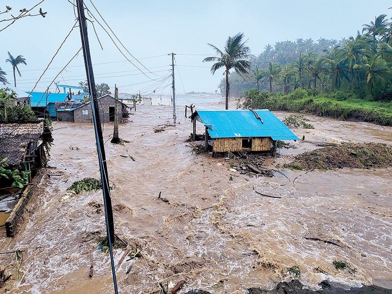
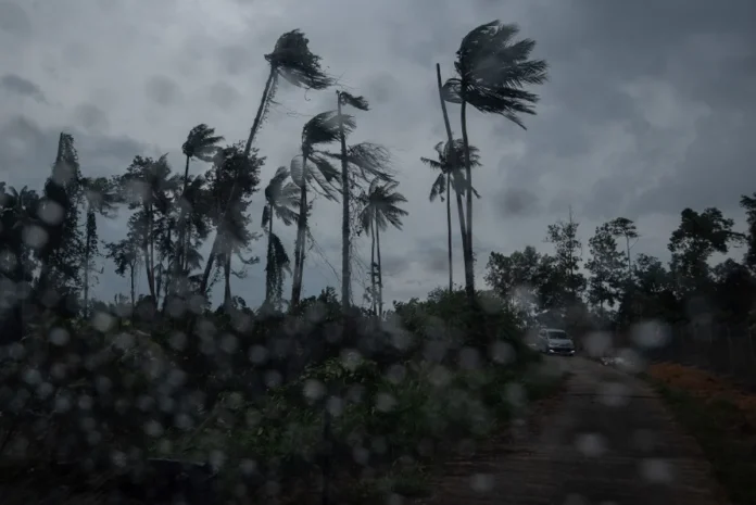
MANILA, Philippines — Wind Signal No. 4 has been lowered to Wind Signal No. 3 across several Luzon provinces as Typhoon Uwan (international name: Fung-wong) weakens over the West Philippine Sea on Monday morning, November 10.
In its 11 a.m. bulletin, state weather bureau PAGASA last spotted Uwan 135 kilometers west northwest of Bacnotan, La Union, packing maximum sustained winds of 130 kilometers per hour (kph) and gusts up to 160 kph.
The typhoon is currently tracking west northwestward at 20 kph over the West Philippine Sea.
Wind signals
After keeping Wind Signal No. 4 over several provinces this past weekend, PAGASA has lowered the alert to Wind Signal No. 3 across three provinces in Luzon.
Signal No. 3 (storm-force winds in 18 hours)
- Ilocos Sur
- the northern and central portions of La Union (Luna, Caba, Santol, Bauang, City of San Fernando, San Juan, Bagulin, Aringay, Bangar, San Gabriel, Burgos, Naguilian, Agoo, Bacnotan, Sudipen, Balaoan)
- the northwestern portion of Pangasinan (Bolinao, Bani, Agno, City of Alaminos, Anda)
Under Wind Signal No. 3, winds ranging from 89 to 117 kph are expected to heavily damage vulnerable structures, uproot large trees, destroy crops and cause power outages.
Individuals residing in these areas are advised to seek shelter in evacuation centers if their homes are not strong enough to withstand the battering winds, leave low-lying areas, and monitor the passage of the typhoon’s “eye wall” and “eye.”
Signal No. 2 (gale-force winds in 24 hours)
- Batanes
- Cagayan including Babuyan Islands
- Isabela
- Quirino
- Nueva Vizcaya
- Apayao
- Abra
- Kalinga
- Mountain Province
- Ifugao
- Benguet
- Ilocos Norte
- the rest of La Union
- the rest of Pangasinan
- Aurora
- Zambales
- Bataan
- Nueva Ecija
- Tarlac
- Pampanga
- Bulacan
Wind Signal No. 2 warns localities of strong winds reaching 62 to 88 kph that may leave structures partially damaged, but galvanized iron roofs peeled or blown off.
Households should have flashlights, extra batteries, matches, lamps, first aid kits and ready-to-eat foods prepared in case of power outages. In case of flooding, families should bring their things to higher ground.
Signal No. 1 (strong winds in 36 hours)
Luzon
- Metro Manila
- Cavite
- Laguna
- Batangas
- Rizal
- Quezon including Polillo Islands
- Oriental Mindoro
- Occidental Mindoro including Lubang Island
- Marinduque
- Romblon
- the northern portion of Palawan (Taytay, Dumaran, El Nido, Araceli), including Calamian and Cuyo Islands
- Camarines Norte
- Camarines Sur
- Catanduanes
- Albay
- Sorsogon
- the northern and western portions of Masbate (City of Masbate, Mobo, Aroroy, Balud, Mandaon, Milagros, Baleno) including Burias and Ticao Islands
Visayas
- Aklan
- Capiz
- the northern and central portions of Antique (Pandan, Libertad, Sebaste, Culasi, Tibiao, Barbaza, Bugasong, Laua-An) including Caluya Islands
Under Wind Signal No. 1, residential and commercial buildings are expected to suffer only light to no damage.
Heavy rainfall reaching 200 millimeters is also anticipated to cause severe and widespread flooding in La Union, Benguet, Pangasinan and Zambales until Tuesday afternoon, November 11.
Meanwhile, Metro Manila, locos Norte, Ilocos Sur, Apayao, Abra, Kalinga, Mountain Province, Ifugao, Batanes, Cagayan, Isabela, Quirino, Nueva Vizcaya, Bataan, Tarlac, Pampanga, Bulacan, Nueva Ecija, Aurora, Cavite, Batangas, Rizal and Occidental Mindoro are likely to receive 50 to 100 millimeters of rain during the same period.
Sea conditions
PAGASA has warned of life-threatening and damaging storm surges, with peaks of up to 3 meters expected in the next 12 hours for low-lying or exposed coastal communities in the Ilocos Region, Cagayan Valley, Central Luzon, Metro Manila, Calabarzon, Mimaropa, Aklan, and Antique.
A gale warning continues over Luzon’s seaboards, with waves reaching 8 meters in Ilocos and western Zambales, 7 meters in Batanes, Cagayan, and Isabela, 5.5 meters in Aurora, the Lubang Islands, Bataan, and Batangas, and 4.5 meters in Occidental Mindoro and the Calamian Islands.
Forecast track
Typhoon Uwan is expected to follow a recurving path, turning northwest on Monday, north on Tuesday, and northeast thereafter. It may strengthen on Monday over the West Philippine Sea before weakening on Wednesday, November 12.
.

Track and intensity forecast of Typhoon Uwan as of 11 a.m. on Nov. 10, 2025.
Uwan is forecast to exit the Philippine area of responsibility Monday night to early Tuesday, with a possible reentry Wednesday evening as it heads toward Taiwan.
….
VIETNAM:
Against the current
….
 Ads by:
 Memento Maxima Digital Marketing