
PHILIPPINES: Typhoon Ambo landfalls in San Policarpio, Eastern Samar
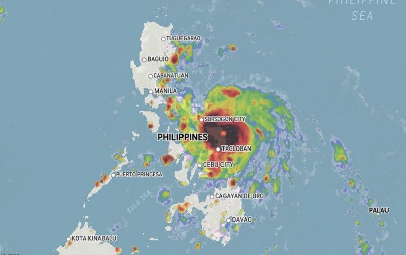
At 4 a.m., the eye of “Ambo” was located 230 kilometers east of Catarman, Northern Samar bearing maximum sustained winds of 150 km per hour and gusts of up to 185 kph.
.
Parts of Samar, Bicol under Signal No. 3
Updated May 14, 2020 – 2:19pm
,

MANILA, Philippines (Updated 8:55 a.m.) — The threat to the Philippine landmass from Typhoon Ambo (international name: Vongfong) has grown as it moves closer to Samar Island, state weather bureau PAGASA said Thursday.
The typhoon—which comes at a time when the Philippines is battling the novel coronavirus pandemic—is forecast to crash into land in the northeastern portion of Northern Samar this afternoon or early evening before heading toward Sorsogon later this evening. It is expected to intensify further before making a landfall.,
.

.
At 7 a.m., the eye of “Ambo” was located 185 kilometers east southeast of Catarman, Northern Samar or 110 east northeast of Borongan City, Eastern Samar bearing maximum sustained winds of 155 km per hour and gusts of up to 190 kph. It is moving west at 15 kph.
Weather forecasters placed these areas under Tropical Cyclone Wind Signal No. 3:
- Sorsogon
- Eastern section of Albay (Legazpi City, Manito, Daraga, Camalig, Jovellar, Santo Domingo, Bacacay, Rapu-Rapu)
- Northern Samar
- Northern portion of Eastern Samar (Jipapad, Arteche, Maslog, Dolores, Oras, San Policarpio, Can-avid, Taft, Sulat, San Julian, Borongan City)
- Northern portion of Samar (Calbayog City, Sta. Margarita, Gandara, Pagsanghan, San Jorge, Matuguinao, San Jose de Buan)
Violent winds and heavy to torrential rains of the eyewall region may start pounding Northern Samar and the northern portions of Samar and Eastern Samar within 12 hours.
Meanwhile, winds between 61 kph and 120 kph may prevail or be experienced in these areas under TCWS No. 2 in 24 hours:
- Southeastern portion of Quezon (Tagkawayan, Guinayangan, Buenavista, San Narciso, Mulanay, San Andres, San Francisco)
- Camarines Norte
- Camarines Sur
- Catanduanes
- Rest of Albay, Burias Islands
- Northern portion of mainland Masbate (Aroroy, Baleno, Masbate City, Mobo, Uson, Dimasalang, Palanas, Cataingan, Pio V. Cruz)
- Biliran
- Rest of Samar
- Rest of Eastern Samar
TCWS No. 1 is hoisted over the following areas, which means winds between 30 and 40 kilometers per hour or intermittent rains may be experienced within 36 hours:
- Southern portion of Aurora (Baler, San Luis, Dingalan)
- Southern portion of Nueva Ecija (Bongabon, Gabaldon, General Tinio, Laur, San Leonardo, Peñaranda, Gapan City)
- Bulacan
- Metro Manila
- Cavite
- Laguna
- Batangas
- Rizal
- Rest of Quezon
- Marinduque
- Eastern portion of Romblon (Banton, Corcuera, Calatrava, San Agustin, Romblon, Magdiwang, San Fernando, Cajidiocan)
- Northern portion of Leyte (Calubian, San Isidro, Tabango, Villaba, Leyte, Kananga, Capoocan, Carigara, Barugo, San Miguel, Babatngon, Tunga, Jaro, Alangalang, Sta. Fe, Tacloban City, Palo, Pastrana, Dagami, Tabontabon, Tanauan, Tolosa, Ormoc City, Matag-ob, Palompon, Merida, Isabel, Albuena, Barauen, Julita, Dulag)
SPACE RESERVE FOR ADVERTISEMENT.
Rainfall outlook
PAGASA said residents of Samar provinces will experience heavy to intense rains with at times torrential rains, while those living in Sorsogon, Albay, Catanduanes, Masbate and the rest of Eastern Visayas will have moderate with at times intense rains.
By Friday, “Ambo” will dump heavy to intense with at times torrential rains over Bicol region. Moderate to heavy with at times intense rains will affect Northern Samar, Quezon, Aurora, Marinduque and Romblon.
“Flooding and rain-induced landslides may occur in highly to very highly susceptible areas during heavy or prolonged rainfall,” PAGASA said.
Storm surge of 1 to 3 meters may be experienced over coastal areas of Northern Samar, Eastern Samar, Samar, Sorsogon, Albay, Catanduanes, Camarines Sur, Camarines Norte, Quezon and Aurora.
Weather forecasters warned that storm surge, along with large swells, may cause “potentially life-threatening coastal inundation.”
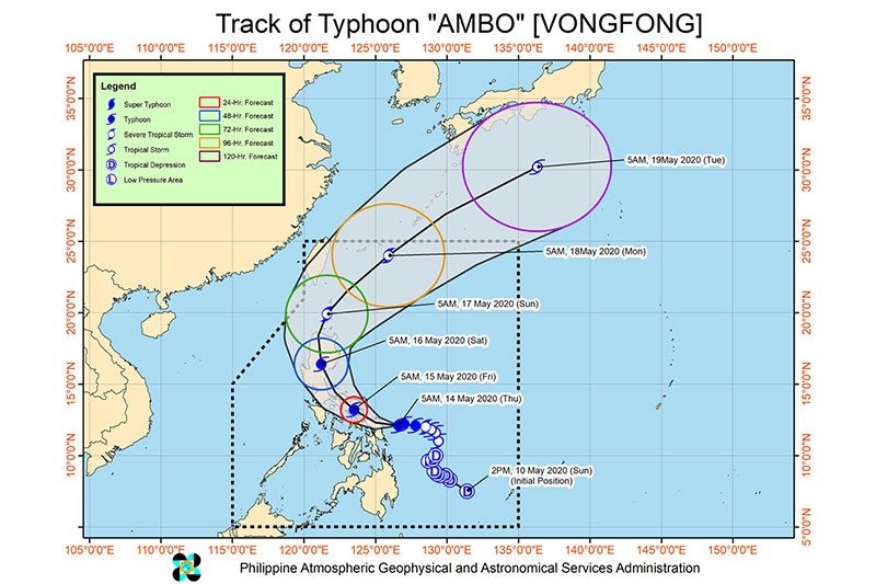
Forecast positions
- Friday morning: In the vicinity of Ligao, Albay
- Saturday morning: In the vicinity of Bambang, Nueva Vizcaya
- Sunday morning: 70 km south southwest of Basco, Batanes
- Monday morning: 565 km northeast of Basco, Batanes
- Tuesday morning: 1,800 km northeast of extreme Northern Luzon (outside Philippine Area of Responsibility)

SIGN UP TO RECEIVE OUR EMAIL